UK weather – live: Met Office issues flooding warning with heavy rain to hit England tonight
There are over 400 of flood warnings and alerts in place across Britain
Your support helps us to tell the story
From reproductive rights to climate change to Big Tech, The Independent is on the ground when the story is developing. Whether it's investigating the financials of Elon Musk's pro-Trump PAC or producing our latest documentary, 'The A Word', which shines a light on the American women fighting for reproductive rights, we know how important it is to parse out the facts from the messaging.
At such a critical moment in US history, we need reporters on the ground. Your donation allows us to keep sending journalists to speak to both sides of the story.
The Independent is trusted by Americans across the entire political spectrum. And unlike many other quality news outlets, we choose not to lock Americans out of our reporting and analysis with paywalls. We believe quality journalism should be available to everyone, paid for by those who can afford it.
Your support makes all the difference.Further yellow weather warnings have been issued by the Met Office, as heavy rain is set to hit large parts of the UK on Saturday evening.
The forecaster expects the weather to impact Newcastle and East Anglia along England’s east coast, with a warning in place from 7pm until midday on Sunday.
Another fresh yellow warning for rain for Cornwall, as well as parts of Devon and Somerset, is due to come into effect at 6pm and last until 6am tomorrow morning.
This comes after an Artic blast wreaked chaos across the UK, with schools closing in north Wales and the Peak District due to snow, ice and sleet.
About 10cm of snow was measured by the Met Office in Kirkwall, Orkney, Scotland, on Thursday, while 9cm was recorded in West Yorkshire.
It comes as heavy rain continues to fall across the country triggering hundreds of flood warnings and alerts across Britain.
As of midday on Saturday, a total of 76 flood warnings and 275 lower level flood alerts are in place for England as heavy rain is set to hit this evening.
 Britain braced for more snow and ice after dozens of schools forced to close
 More snow, ice and rain forecast after schools shut amid weather warnings
 Schools shut as snow falls across parts of the UK – and warnings continue
 Snow mapped: Where will wintry showers hit UK this week as temperatures to plunge to -10C
Five day weather forecast
Today:
Some fog during the morning, then many staying dry with sunny spells. Showers at times, mainly in the southwest, with outbreaks of rain, sleet and hill snow affecting the north and east of Scotland. Feeling cold in Scotland. Milder elsewhere.
Tonight:
Some clear spells overnight where fog may develop. In the southwest, turning windy with further showers. Rain clearing Scotland, with further rain across eastern England. Feeling chilly for many.
Sunday:
Patchy mist and fog to start. Showers continuing in the southwest, some of these heavy and possibly thundery at times. Cloudy for some eastern areas with rain possible. Average temperatures.
Outlook for Monday to Wednesday:
Breezy on Monday with sunny spells and showers. Rain at times on Tuesday and Wednesday but some drier interludes too. Temperatures around average, though mild in the south.
Two new weather warnings issued by Met Office
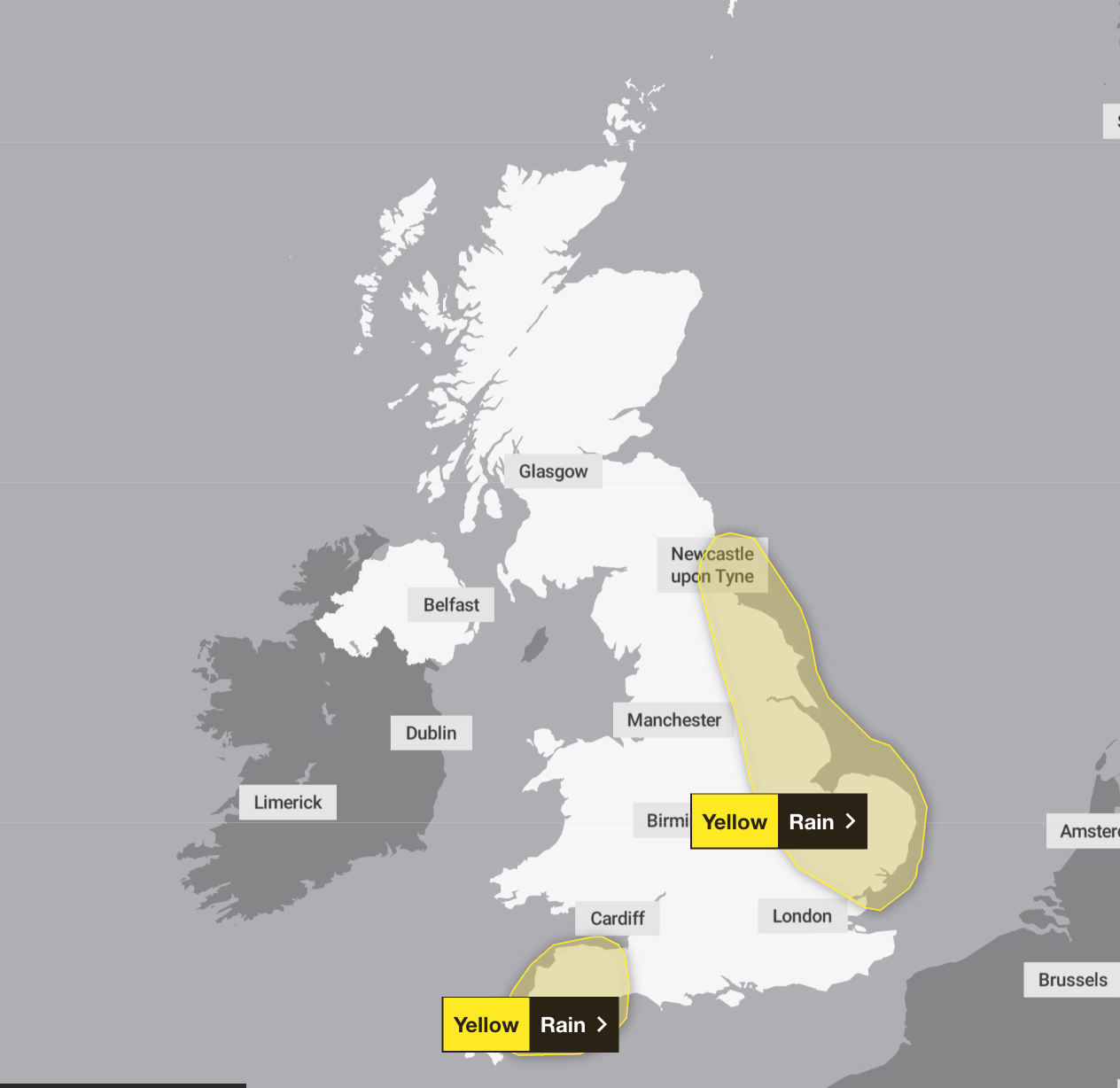
Two new yellow weather warnings for heavy rain have been issued across large parts of England, as the Met Office warn that people could face travel disruption and some flooding.
One warning covers Newcastle and its surrounding areas down to East Anglia, along England’s east coast, and is due to come into force at 7pm and lasts until 12pm on Sunday.
Another fresh yellow warning for rain covers much of Cornwall as well as parts of Devon and Somerset. That warning begins at 6pm on Satuday and is due to last until 6am tomorrow morning.
Mapped: Where rain is expected to hit the UK this evening
A total of 76 flood warnings and 275 lower level flood alerts are currently in place for England as heavy rain is set to hit this evening.
What to expect in heavy rain
The Met Office has warned that the yellow weather warning for heavy rain could lead to the flooding of a few homes and businesses, while spray on the roads could make journeys take longer.
Bus and train services might alos be affected, with delays possible.
The Met Office warn that snow could still fall in Scotland
In a post on social media, the Met Office warned that snow could still fall in higher areas of Scotland.
Yellow weather warning for snow across north of Scotland
A yellow weather warning for snow has been issued in the north of Scotland.
The warning is in place until 3pm on Saturday and will cover most of Aberdeenshire, Moray and the Highlands.
The Met Office has told residents there could be a small chance of power cuts, and other services such as mobile phone coverage may be affected.
Read the full article here

Why are storms named?
For the 2023/24 season, the way the Met Office and Irish service Met Éireann names storms has changed.
Previously, names were drawn from a shortlist of favourites chosen by the public.
But now, the storms will be named after those working to protect people from severe weather around the UK.
Along with Met Eireann in Ireland and KNMI, the Dutch weather service, meteorologists name storms when they are expected to have a “medium” or “high” impact on people in the UK, Ireland or the Netherlands.
Will Lang, head of situational awareness at the Met Office, said: “This is the ninth year of us naming storms and we do it because it works.
“Naming storms helps to ease communication of severe weather and provides clarity when people could be impacted by the weather.”
Surface flooding and disruption to travel possible
“Spells of rain will lead to some flooding and disruption to travel,” the Met Office has said for the north eastern alert around Newcastle and East Anglia.
A second yellow weather warning for Cornwall and parts of Devon and Somerset is also due to come in force at 6pm this evening.
For this aler, they added: “Heavy showers may lead to some surface water flooding and disruption to travel.”
We’re pausing our live coverage of the weather but keep checking independent.co.uk for the latest updates.
Join our commenting forum
Join thought-provoking conversations, follow other Independent readers and see their replies
Comments