UK weather live: Dozens more flood warnings issued across England after a month’s rain falls in 24-hour deluge
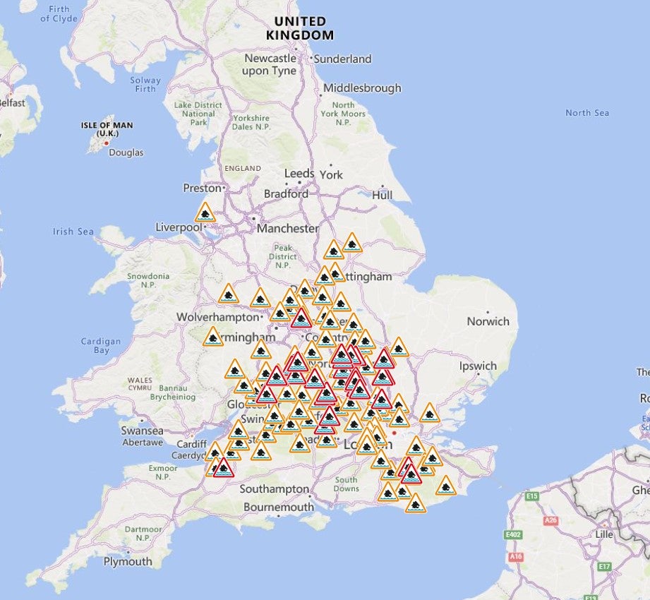
The Environment Agency has issued 32 flood warnings after Monday’s deluge
Your support helps us to tell the story
My recent work focusing on Latino voters in Arizona has shown me how crucial independent journalism is in giving voice to underrepresented communities.
Your support is what allows us to tell these stories, bringing attention to the issues that are often overlooked. Without your contributions, these voices might not be heard.
Every dollar you give helps us continue to shine a light on these critical issues in the run up to the election and beyond

Eric Garcia
Washington Bureau Chief
Flood warnings continue across parts of the UK, after extreme rainfall on Sunday and Monday caused roads and schools to close and wreaked transport chaos on commuters.
The autumn equinox coincided with heavy downpours as the Met Office warned “heavy rain is expected to produce some flooding”, with the Environment Agency issuing 32 warnings and 94 flood alerts.
On Monday, an amber and yellow weather warning remained in place across most of England and Wales until the end of Monday, with several schools up and down the country expected to remain closed on Tuesday.
The A421 in Bedfordshire is closed in both directions between A6 and M1 J13 due to flooding. Also, the A505 in Hitchin, Elton Way in Watford and the A404 between Chorleywood and Rickmansworth were all shut on Monday morning for the safety of road users, Hertfordshire County Council said.
Dan Harris, deputy chief meteorologist at the Met Office said on Wednesday and Thursday “unsettled weather is set to return as further frontal systems move in from the Atlantic, bringing showers or longer spells of rain to many parts of the UK”.

Environment Agency issue 32 flood warnings
The Environment Agency have issued 32 flood warnings across parts of the UK, and have warned that further local inland flooding is possible across England on Tuesday.
Areas that are at risk of flooding include areas close to the River Great Ouse, and certain parts of Northmapton and Leighton Buzzard.
As of 8am, a further 94 flood alerts had also been issued across large parts of England, including the Midlands and the south-east.
Main Hampshire commuter line to London blocked
The main line from Bournemouth, Southampton and Winchester to London Waterloo will have no trains running between Basingstoke and Winchester “until approximately 10am” according to National Rail.
South Western Railway, which runs most of the trains on the affected stretch of line, warned disruption would last even longer, saying: “Train services running through these stations may be cancelled, delayed or revised. Disruption is expected until 12 noon.”
Some trains may be re-routed away from the affected stretch of track, though this will sharply increase journey times.
CrossCountry trains from Bournemouth and Southampton to Birmingham and Manchester are also affected.
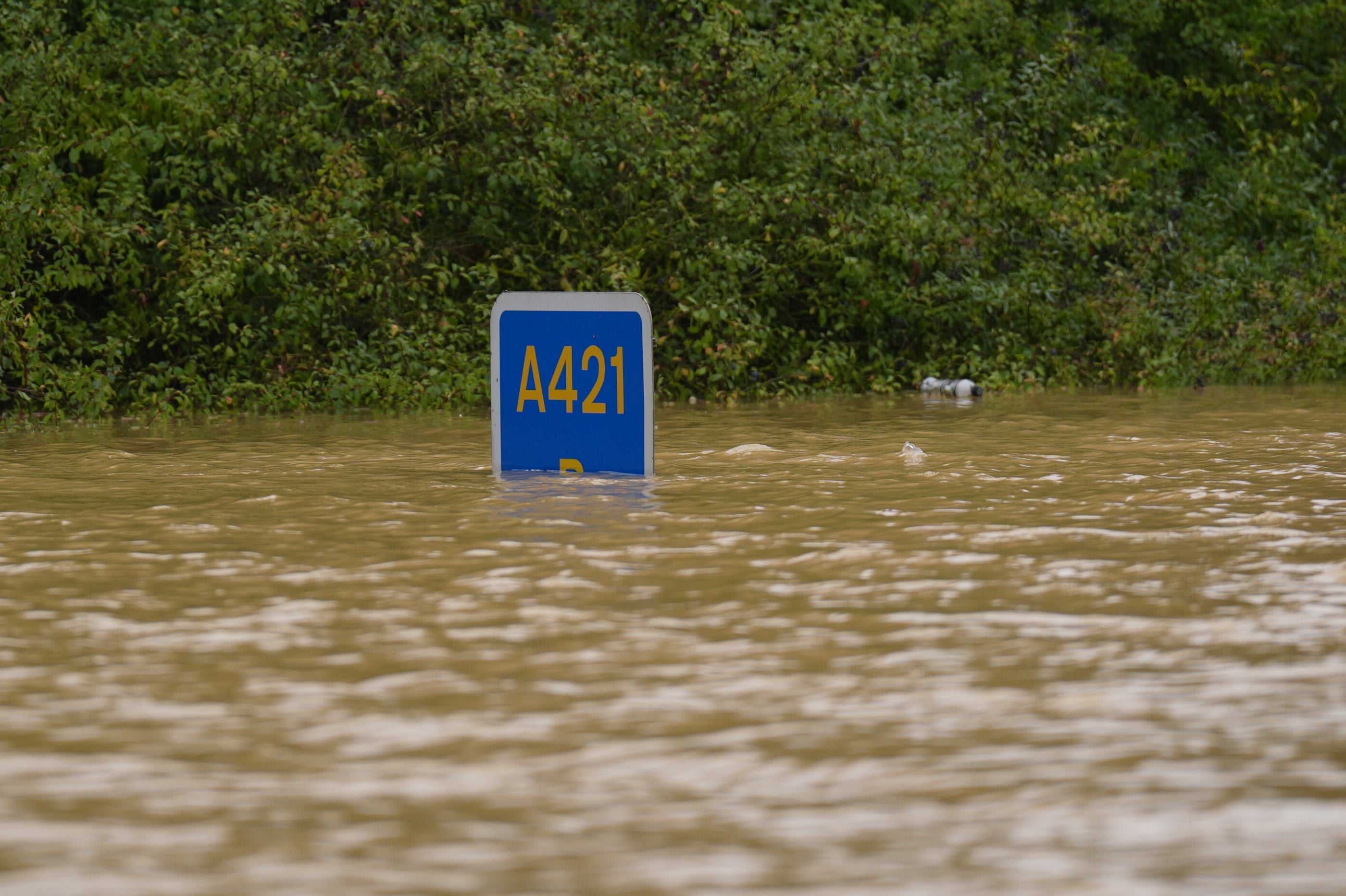
'We cannot provide a timeline for the A421 to reopen' – National Highways
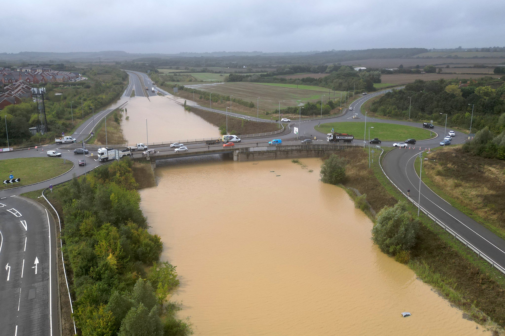
On the roads, the key problem remains in Bedfordshire: the closure of the A421 between the A6 at Bedford and junction 13 of the M1 due to flooding.
National Highways says: “Following spells of torrential rain, flooding occurred at Marston Moretaine on the evening of Sunday 22 September with water levels of up eight feet recorded.
“This has severely impacted efforts to clear floodwater from the carriageway. National Highways service providers continue to work at scene and at present a number of articulated tankers and pumping equipment are in use as efforts to clear the road continue.
“At this stage we cannot provide a timeline for the road to reopen. Three vehicles that have been abandoned in the flooded section will also need to be recovered before the carriageway can be fully re-opened.”
In addition, the A5 in Buckinghamshire is closed northbound at Milton Keynes due to flooding caused by heavy rainfall.
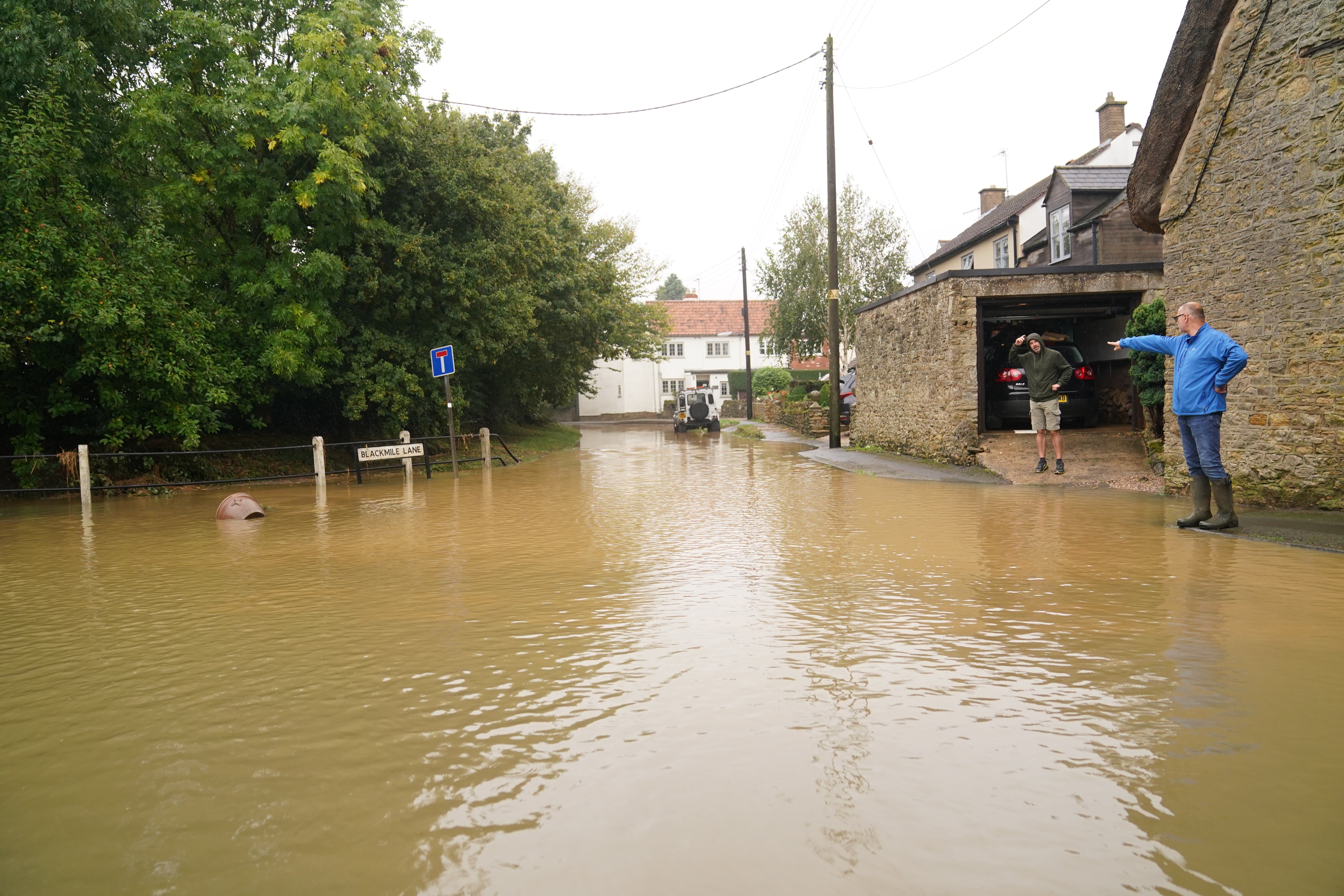
Flash floods hit parts of Britain as month’s worth of rain to fall in 24 hours
Parts of Britain have been struck by flash floods after some areas saw more than a month’s worth of rain in 24 hours.
Heavy rainfall has seen parts of Northamptonshire, Bedfordshire and London submerged – causing widespread travel disruption and damage to properties.
According to the Environment Agency, at least 45 properties have flooded across Hertfordshire, Bedfordshire, Kent and the Home Counties.
William Warnes reports:

Flash floods hit parts of Britain as month’s worth of rain to fall in 24 hours
Heavy rainfall has seen parts of Northamptonshire, Bedfordshire and London submerged causing widespread travel disruption and damage to properties.
Cold arctic air to bring drop in temperatures
A blast of cold arctic air will bring colder temperatures towards the end of the week.
The Met Office says temperatures will decline, “leading us into a brief cold spell by the end of the week”. A more unsettled week lies ahead, with colder temperatures forecast.
It will feel chilly on Wednesday, followed by an unsettled and cold day on Thursday and cold and windy weather on Friday, the Met Office says.
A change of feel is on the way as temperatures decline, leading us into a brief cold spell by the end of the week pic.twitter.com/pF4NgRdX0k
— Met Office (@metoffice) September 23, 2024
Advice from Environment Agency
Environment Agency flood duty manager Sarah Cook said “persistent heavy rain and thunderstorms” could lead to some property flooding and travel disruption.
She said: “Persistent heavy rain and thunderstorms could lead to significant surface water flooding on Monday across parts of England.
“The impacts could include localised flooding in urban areas and fast-responding catchments, including some property flooding as well as travel disruption. The risk from river flooding remains low.
“Environment Agency teams are out on the ground and ready to support local authorities in responding to surface water flooding.
“We urge people to plan their journeys carefully, follow the advice of local emergency services on the roads and not to drive through flood water - it is often deeper than it looks and just 30cm of flowing water is enough to float your car.
“People should check their flood risk, sign up for free flood warnings and keep up to date with the latest situation as well as following EnvAgency on X, formerly Twitter, for the latest flood updates.”
Cannes hit by flash flooding with more severe storms possible
A little look across the Channel to France as Cannes has also been hit with flash floods, pushing cars through the streets and leaving the French Riviera city known for its film festival on high alert.
There were no injuries from the deluge in the French southeast region, where in 2015 at least 19 people died in flash floods and tens of thousands had power blackouts.
The situation was expected to return to normal by the end of the morning as the storm continued to move east, its town hall spokesperson said.
The city’s mayor David Lisnard told BFM TV he would be seeking an explanation from other authorities because the city only received a government alert an hour after the storm began.
Why has it been so wet?
The BBC’s weatherman Matt Taylor has explained why it has been so wet. He cites a buckle in a southerly running jet stream combined with a low-pressure system drifting north out of Spain and France to form an area of very unstable air.
Coupled with a feed of warm and humid air from central Europe meant “the recipe was right for storm clouds loaded with plenty of moisture.”
He continued: “With temperatures higher for a while than we would normally expect at this stage of the year, the storms have contained extra energy and have been intense. As the low pressure system then stuck over the southern half of the UK, the story continued over a number of days.”
Latest pictures

More than 100 flood alerts and warnings in place
There are currently 22 flood warnings in place this evening, covering areas where flooding is actively expected to happen.
There are another 87 flood alerts in place, which means that flooding is possible.
Both lists have been steadily rising throughout the day.
Subscribe to Independent Premium to bookmark this article
Want to bookmark your favourite articles and stories to read or reference later? Start your Independent Premium subscription today.
Join our commenting forum
Join thought-provoking conversations, follow other Independent readers and see their replies
Comments