Hurricane Nigel expected to ‘rapidly intensify’ and become major storm by Tuesday: Latest tracker
Hurricane Nigel is forecast to ‘rapidly intensify’ to become a Category 3 hurricane
Your support helps us to tell the story
From reproductive rights to climate change to Big Tech, The Independent is on the ground when the story is developing. Whether it's investigating the financials of Elon Musk's pro-Trump PAC or producing our latest documentary, 'The A Word', which shines a light on the American women fighting for reproductive rights, we know how important it is to parse out the facts from the messaging.
At such a critical moment in US history, we need reporters on the ground. Your donation allows us to keep sending journalists to speak to both sides of the story.
The Independent is trusted by Americans across the entire political spectrum. And unlike many other quality news outlets, we choose not to lock Americans out of our reporting and analysis with paywalls. We believe quality journalism should be available to everyone, paid for by those who can afford it.
Your support makes all the difference.Hurricane Nigel has strengthened slightly overnight and is set to intensify further, according to the latest advisory from the National Hurricane Center.
Nigel, the sixth hurricane to form in the Atlantic Ocean this season, developed into a Category 1 storm yesterday and was forecast to “rapidly intensify” to become a Category 3 hurricane.
At the moment, Nigel has sustained winds of 80mph (130kph) but forecasters in the National Weather Service (NWS) and National Hurricane Center expect the storm to have sustained winds of at least 111mph as it grows.
Nigel was located approximately about 875miles (1,410km) east-southeast of Bermuda and was moving northwest at a speed of 12mph (19kph).
The hurricane is not expected to make landfall and no warnings or watches have been issued.
As of now, the National Hurricane Center predicts Nigel will veer off right into the open Atlantic Ocean by Wednesday morning.
Nigel developed shortly after Hurricane Lee landed in Nova Scotia as a post-tropical storm.
Hurricanes are getting stronger. Here’s why
As the global average temperature increases and sea levels rise, tropical cyclones - the catch-all term for hurricanes and typhoons - are expected to become stronger and the damage more catastrophic, scientists say.
Ethan Freedman and Louise Boyle report:

Hurricanes are getting stronger. Here’s why
Typhoon Mawar could deliver the biggest hit in two decades to Guam, a US territory in the Pacific
National Hurricane Center says no warnings in effect
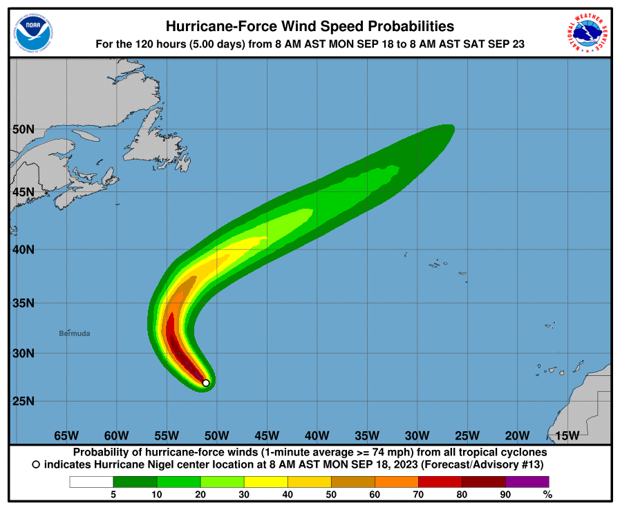
In their latest update on Hurricane Nigel, the National Hurricane Center (NHC) said the location of the storm does not affect land.
As of 11am ET on Monday, there are no coastal watches or warnings in effect regarding Hurricane Nigel.
Though it is currently a Category 1 and expected to rapidly intensify, the storm’s expect path is to remain in the middle of the Atlantic Ocean.
Watch: Timelapse of Nigel going from tropical depression to hurricane
Why destructive hurricanes often start with the letter ‘I’
The World Meteorological Organization (WMO) issues alphabetical lists of names to label hurricanes each year - one for each of the world’s three oceanic regions.
Faiza Saqib reports:

Why destructive hurricanes like Idalia often start with the letter ‘I’
Idalia tore through Florida, Georgia and the Carolinas this week
How are hurricanes classified?
When a tropical depression reaches sustained winds between 74 and 95 miles per hour it is officially classified as a Category 1 hurricane on the Saffir-Simpson Hurricane Wind Scale.
After that, hurricanes can reach up to a Category 5 depending on its sustained winds, according to the National Hurricane Center.
Category 1 – Winds of 74 to 95 mph. “Very dangerous winds will produce some damage.”
Category 2 – Winds of 96 to 110 mph. “Extremely dangerous winds will cause extensive damage.”
Category 3 – Winds of 111 to 129 mph. “Devastating damage with occur.”
Category 4 – Winds of 130 to 156 mph. “Catastrophic damage will occur.”
Category 5 – Winds of 157 mph or higher. “Catastrophic damage will occur.”
Hurricane Nigel may weaken on Wednesday
The National Hurricane Center predicted Hurricane Nigel to potentially weaken after becoming a major hurricane on Wednesday.
“Nigel is forecast to rapidly strengthen into a major hurricane on Tuesday,” the NHC wrote in an advisory on Monday afternoon.
They added: “A gradual weakening trend could start on Wednesday.”
Hurricane Nigel approximately 800 miles from Bermuda
Hurricane Nigel is currently picking up speeds in the middle of the Atlantic Ocean.
As of Monday afternoon, the storm is about 810 miles from Bermuda, the National Hurricane Center said.
With sustained winds of 80 mph, Nigel is a Category 1 hurricane – though it is expected to rapidly intensify to a Category 3 by Tuesday.
No warnings or watches have been issued as of Monday afternoon.
Where did Hurricane Lee end up?
On Saturday, the storm was downgraded from a hurricane to a post-tropical cyclone.
Kelly Rissman reports:

Hurricane Lee makes landfall
Earlier on Saturday, the storm had been downgraded from a hurricane to a post-tropical cyclone
Hurricane wind speed possibility
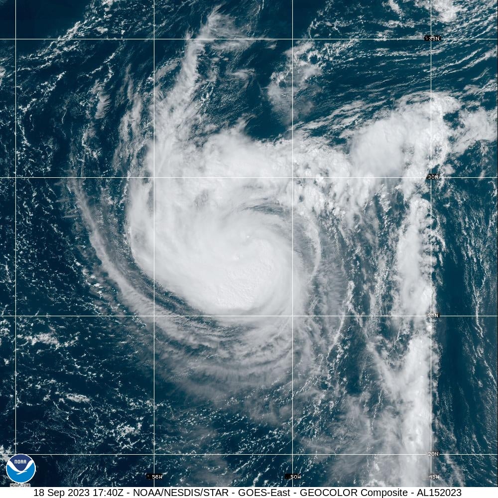
Hurricane Nigel has ‘somewhat ragged-looking eye'
The National Hurricane Center (NHC) described Hurricane Nigel as having a “somewhat ragged-looking eye” as of Monday afternoon.
“Nigel is exhibiting a somewhat ragged-looking eye on satellite imagery, surrounded by bands of very deep convection with cloud tops to -80 deg C. High-level outflow has become a bit restricted over the northeastern quadrant of the circulation, but overall the system continues to become better organized. “
Join our commenting forum
Join thought-provoking conversations, follow other Independent readers and see their replies
Comments