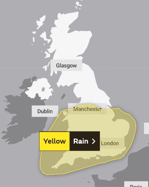
UK weather: Torrential downpours as heavy rain warning issued by Met Office
Wet and windy weather marks the end of summery October as yellow weather warning issued


Downpours of heavy rain are expected to cause flooding and travel chaos in parts of the UK in a notable end to the unseasonably warm spell this month.
Strong winds of upto 60mph are set to hit the southern coasts of England as thunderstorms are likely to shower over the region, while blustering gales of 45-50mph will whip inland.
The Met Office has issued a yellow weather warning for rain from 9pm on Thursday to 8pm on Friday.
Met Office spokesperson Oli Claydon said Thursday evening will see “increasing cloud and then rain moving into the south-west of the UK”.
He added that it would spread north east overnight and “bring rain to most parts of England and Wales through tonight and tomorrow”.
In the wettest spots 30-50mm of rainfall is possible, and some western parts of Wales over higher ground could see up to 70mm.
Mr Claydon said the rain would clear to the south east of the UK by tomorrow evening, resulting in “much cooler conditions as we move into the weekend”.
“It will feel very different, especially in the south, where we had those very mild conditions last weekend,” he added.

Dr Kate Marks, flood duty manager at the Environment Agency, said: “Heavy rain means surface water flooding is probable for parts of the South West later today.
“As the rain spreads north and east, minor surface water and river flooding is also probable across England on Friday, potentially continuing into the weekend.
“Environment Agency teams will be out on the ground, undertaking preparatory operational activity to minimise the impacts of flooding where possible.”

Aimee Thomas, duty tactical manager at Natural Resources Wales, said they were asking people to be “alert for potential localised flooding”.
“Surface water flooding is expected, which could cause localised flooding of roads, and flooding from drains, ditches and small streams. The rain could also lead to the issuing of flood alerts and warnings if rivers reach trigger levels,” she added.
UK five day forecast
This Evening and Tonight:
Rain, often heavy and persistent, affecting much of England and Wales, and turning windy. Another band of rain moving south across Northern Ireland and Scotland with clear spells and showers to follow. A mild night for many.
Friday:
Unsettled on Friday with heavy rain and strong winds for many. Rain slowly clearing southeast into the late afternoon and evening. Becoming colder from the northwest with sunny spells.
Outlook for Saturday to Monday:
Plenty of autumnal sunshine through the weekend and into Monday. Scattered showers at times but feeling much colder, especially overnight with a frost likely for some.
Join our commenting forum
Join thought-provoking conversations, follow other Independent readers and see their replies
Comments


Bookmark popover
Removed from bookmarks