UK weather map: Where freezing rain, snow and ice will hit this weekend as temperatures plummet
Freezing rain is rarely seen in the UK but it can bring down trees and ground planes
Your support helps us to tell the story
From reproductive rights to climate change to Big Tech, The Independent is on the ground when the story is developing. Whether it's investigating the financials of Elon Musk's pro-Trump PAC or producing our latest documentary, 'The A Word', which shines a light on the American women fighting for reproductive rights, we know how important it is to parse out the facts from the messaging.
At such a critical moment in US history, we need reporters on the ground. Your donation allows us to keep sending journalists to speak to both sides of the story.
The Independent is trusted by Americans across the entire political spectrum. And unlike many other quality news outlets, we choose not to lock Americans out of our reporting and analysis with paywalls. We believe quality journalism should be available to everyone, paid for by those who can afford it.
Your support makes all the difference.Britain is braced for freezing rain this weekend - a rare phenomenon which can bring down trees and ground planes, the Met Office warned.
The rare weather event - commonly known as ice storms in North America - is not often seen in the UK because the conditions needed for it are quite specific.
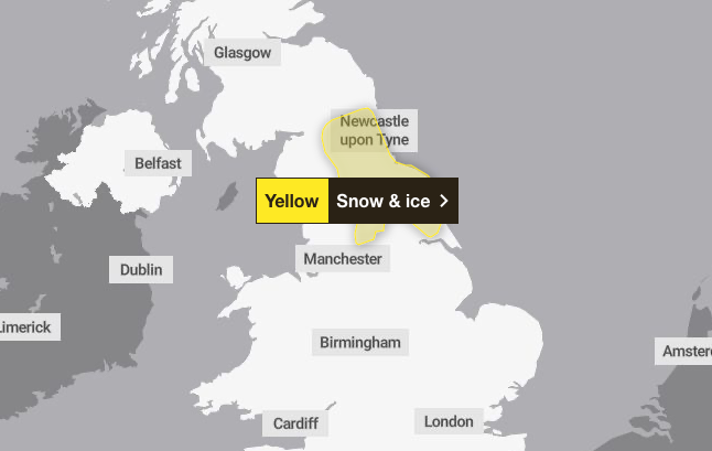
It comes as the Met Office issued a yellow weather warning for snow and ice across parts of the UK this weekend.
Forecasters said Yorkshire and the Humber, northwest England and northeast England will be affected between 6am and 2pm on Saturday.
Freezing rain is rainfall that has become “supercooled” as it falls from the sky, travelling through various temperatures in the atmosphere.
It starts as sleet or hail high up in the atmosphere, but as it travels down it melts through a layer of warmer air, then refreezes again through a layer of colder air near the surface.
These conditions could be seen in Britain over the coming days, as high pressure to the north and east of the country continues to bring cloud and cold air.
Met Office forecaster Honor Criswick said: “There is a chance we could see some hill snow as this area of rain moves into colder air.
“There is even a chance we could see some freezing rain, so do take care as there could be some icy stretches by the morning.
“But for many, most towns and cities will just about drop below freezing, so colder nights are likely compared to recent nights.”
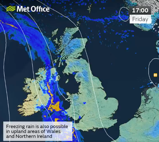
She said tonight would see a “chillier night on offer compared to recent nights - likely to see some frost, possibly even some ice too, some outbreaks of rain starting to push into Cornwall, parts of Northern Ireland, perhaps the far South West of Wales later”.
Ms Criswick continued: “Still continuing to see that risk of freezing rain too, so still a chance of some icy stretches.
“But away from this cloud, an area of rain - that cloud breaking up a bit more so perhaps seeing a bit more sunshine by the time we reach tomorrow afternoon.
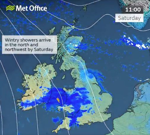
“But temperatures remain fairly similar if not a touch below in some places. So despite a chance of seeing a little bit more sunshine on the cards tomorrow, it is still going to be feeling chilly so we'll need to wrap up warm to enjoy it.”
Freezing rain can produce striking effects, forming as rain drops spread out momentarily across a surface before freezing and encasing the surface in a layer of clear ice.
The weight of the ice can sometimes be heavy enough to bring down trees and power lines, and the glaze of ice on the ground effectively turns roads and pathways into an ice rink, according to the Met Office.
It can also prove extremely hazardous for aircraft, with the chance of icicles forming across the wings of an aeroplane.
The ice is very clear, often referred to as black ice, because it is so difficult to see, making it treacherous for pedestrians and drivers.
Join our commenting forum
Join thought-provoking conversations, follow other Independent readers and see their replies
0Comments