UK weather: Heatwave set to be ‘hotter than Turkey’ as temperatures soar to 26C
Britons are in for a stretch of warm weather over the next two weeks, the Met Office says

Britons are set to swelter over the next two weeks as forecasters predict temperatures will be be hotter than Turkey.
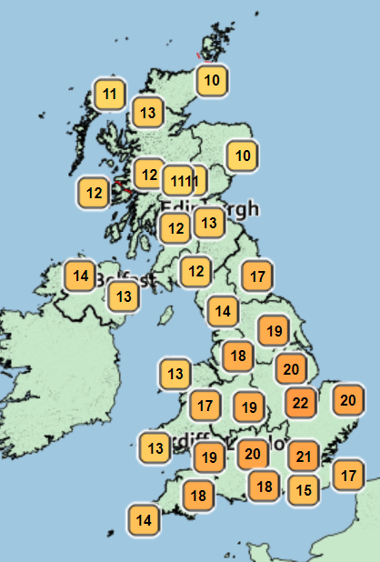
Monday’s weather is set to be highest during the start of this week as temperatures soar to 22C in parts of the South East, which is hotter than Turkey’s capital Istanbul today.
And the heat will only increase next week as forecasters predict highs of 26C throughout the week.

Temperatures are expected to peak on Tuesday, 17 May at 26C in London, and 25C for the next two days.
The rest of this week will be slightly milder with highs sitting between the mid and high teens, before Sunday turns up the heat again as 23C is expected, according to BBC weather.
Met Office spokesperson Annie Shuttleworth said: “It’s likely we’ll see those warm and much warmer than average temperatures across the UK.
“Ultra-violet light levels will likely be high.”
Before that though, this week is expected to be cooler after Monday’s 22C peak.
Tuesday will see a band of cloud and light rain across south England with sunny spells and showers following on for the north and west.
Showers will continue on Wednesday with rain mostly in the south and west, the Met Office forecast says.
There will be cloudier conditions on Wednesday with moderate south westerly winds, but it will still feel warm despite the cloud.
Thursday will be a drier but cloudier day and any rain and showers will be more isolated before warmer conditions return in time for the weekend.

Met Office outlook this week
Today:
Scotland and Northern Ireland cloudy and windier with rain at times, this reaching northwestern parts of both England and Wales later. Otherwise England and Wales mostly fine with sometimes hazy sunshine, leading to a warm day especially in the southeast.
Tonight:
Rain will continue southeastwards, although easing and probably not reaching the southeast corner of England. A much milder night in the south. Further north, cooler with clear spells and showers.
Tuesday:
Cloud and patchy rain clearing southeast England, then most southern areas reasonably warm with some sunshine, just the odd light shower. Further north sunny intervals and showers, perhaps heavy.
Outlook for Wednesday to Friday:
Scattered showers affecting Scotland and Northern Ireland and rather cool. Spell of rain on Wednesday affecting England and Wales then becoming drier and brighter with temperatures around average.
Join our commenting forum
Join thought-provoking conversations, follow other Independent readers and see their replies
Comments
Bookmark popover
Removed from bookmarks