Red weather warning mapped: Where and when will Storm Babet will hit?
Storm Babet barrels towards UK bringing 'exceptional' rain this week
Your support helps us to tell the story
From reproductive rights to climate change to Big Tech, The Independent is on the ground when the story is developing. Whether it's investigating the financials of Elon Musk's pro-Trump PAC or producing our latest documentary, 'The A Word', which shines a light on the American women fighting for reproductive rights, we know how important it is to parse out the facts from the messaging.
At such a critical moment in US history, we need reporters on the ground. Your donation allows us to keep sending journalists to speak to both sides of the story.
The Independent is trusted by Americans across the entire political spectrum. And unlike many other quality news outlets, we choose not to lock Americans out of our reporting and analysis with paywalls. We believe quality journalism should be available to everyone, paid for by those who can afford it.
Your support makes all the difference.Parts of the UK have been warned to brace for “exceptional” rain, severe flooding and powerful winds as Storm Babet barrels in from the Atlantic this week.
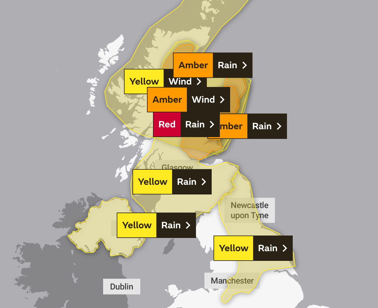
The Met Office has issued a flurry of weather alerts covering Northern Ireland, most of Scotland and reaching the south coast of England – including a rare red alert for rain in force on Thursday and Friday – as it warns of devastating impacts from the second named storm of the season.
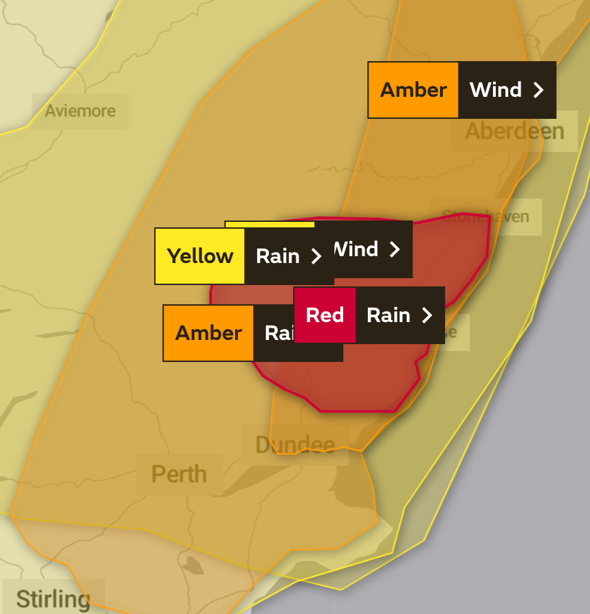
Stretching 30 miles along Scotland’s eastern coast from Carnoustie to Stonehaven, those living in the area under the red alert have been told to expect a “danger to life from fast flowing or deep floodwater”, extensive flooding of homes, and for some buildings to suffer damage or collapse.

Communities could be completely cut off for several days, with power cuts and other essential services such as gas, water and mobile phone signal also being lost, the Met Office warned.
More than 100mm of rain is widely expected in this area, with as much as 250mm of rain forecast to fall in some places – more than three times the October monthly average of 75mm in Arbroath, a coastal town which sits within the area affected by the alert.
It is the first red warning for rain issued in the UK since Storm Dennis in February 2020, which killed five people and flooded more than 1,400 homes and businesses. Coming a week after Storm Chiara, the two cyclones brought a total of 250mm to some areas.
Storm Babet made landfall on Wednesday, with a weather warning for heavy rain coming into force at 2pm across Northern Ireland.
It is set to reach Scotland overnight, with all of the country bar the Hebrides subject by 6am on Thursday to warnings of a mixture of very strong easterly winds and heavy rain set to last until Saturday. Gusts in excess of 70mph are likely.

Those alerts are more severe in east, north and central Scotland, where Aberdeen, Perth, Dundee and a large area north of Inverness are warned of life-threatening floodwaters, and the loss of power and other services, including travel routes.
The storm will start to reach its peak at 6pm on Thursday when the more dangerous red alert comes into force on the east coast.
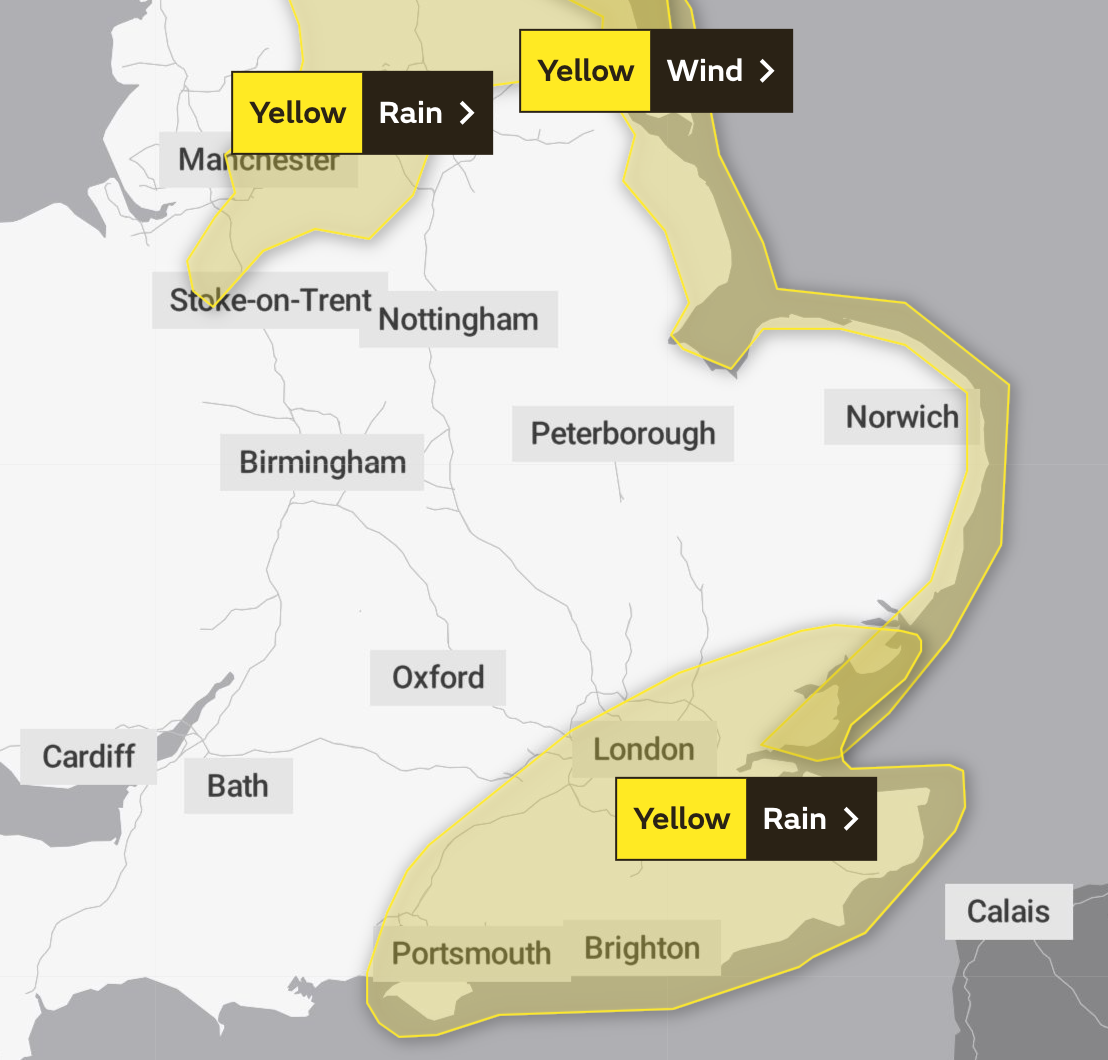
Simultaneously, the rains are also expected to have moved deep into England by 6pm, with an alert in place from England’s northern border to nearly as far south as Stoke-on-Trent, and covering Leeds, Manchester and Sheffield, set only to abate at 6am on Saturday.
The picture is much the same on Friday, by which point nearly the entire eastern coast of the UK will be subject to a warning of strong winds which could impact travel and cause large waves, in place until midday on Saturday.

A second area of low pressure will also arrive from the south on Friday, with London and southeastern counties as far west as Portsmouth and the Isle of Wight affected until 8pm, with the potential for flooding to affect homes and businesses.
In excess of 50mm of rain is possible in some places, close to London’s monthly average.


Join our commenting forum
Join thought-provoking conversations, follow other Independent readers and see their replies
Comments