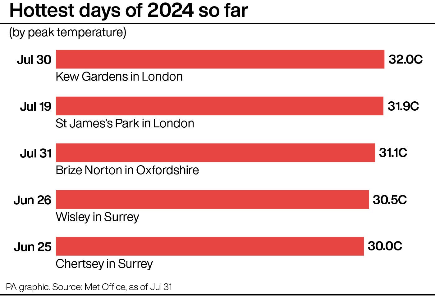
Met Office weather warning as UK braced for flooding, hail and 30C heat
There is a risk of more than 60mm of rainfall in two to three hours which could be accompanied by lightning

Your support helps us to tell the story
From reproductive rights to climate change to Big Tech, The Independent is on the ground when the story is developing. Whether it's investigating the financials of Elon Musk's pro-Trump PAC or producing our latest documentary, 'The A Word', which shines a light on the American women fighting for reproductive rights, we know how important it is to parse out the facts from the messaging.
At such a critical moment in US history, we need reporters on the ground. Your donation allows us to keep sending journalists to speak to both sides of the story.
The Independent is trusted by Americans across the entire political spectrum. And unlike many other quality news outlets, we choose not to lock Americans out of our reporting and analysis with paywalls. We believe quality journalism should be available to everyone, paid for by those who can afford it.
Your support makes all the difference.A mix of extreme weather is set to sweep across parts of the UK on Thursday as temperatures reach up to 30C, the Met Office has said.
Thunderstorms and hailstorms are forecast for areas.
The forecaster issued a yellow warning for thunderstorms covering the majority of England and Wales for the whole day, which may lead to sudden flooding and disruption to transport.
The storms are expected to affect south-east England and parts of East Anglia during the early hours of Thursday when between 25mm and 40mm of rain could fall in an hour.
There is a small risk of more than 60mm of rainfall in two to three hours which could be accompanied by frequent lightning, the Met Office added.
The Met Office predicts heavy and thundery showers across parts of Wales, the Midlands and northern England which will ease towards midday.

Scattered heavy showers and thunderstorms are expected across Thursday afternoon and evening across parts of central, southern and eastern England and South Wales which could produce 50mm of rain or more in one to two hours as well as gusty winds, large hailstones and the risk of flooding.
Met Office meteorologist Simon Partridge said: “The problem is that the winds are very light as well, so where you see those heavy thundery showers, there’s not really much wind to blow them through as often as when you have showers and it’s a fairly breezy day – you don’t get much of the rain from one particular shower.
“Where those thunderstorms occur, that local area will probably get pretty much all of the rain that that thunder cloud is holding – so there could be very locally heavy downpours which bring along the risk of localised flooding and surface water problems for transport networks.”
Among the storms, there will be “a lot of fine, dry and sunny weather” and Thursday will feel “very warm, very humid and very muggy”, he added.
Highs of up to 30C are expected from Hampshire up to north London while western Scotland is predicted to experience the coolest temperatures of the day of between 17C and 18C.
Friday is forecast to be “mostly dry with plenty of sunny spells” with temperatures of up to 28C followed by “generally dry and still quite warm” weather over the weekend, Mr Partridge added.