Rare amber cold health warning alerts in place as Britain hit by ‘freezing fog patches’
The Met Office says it will be a ‘very cold and frosty’ end to the weekend
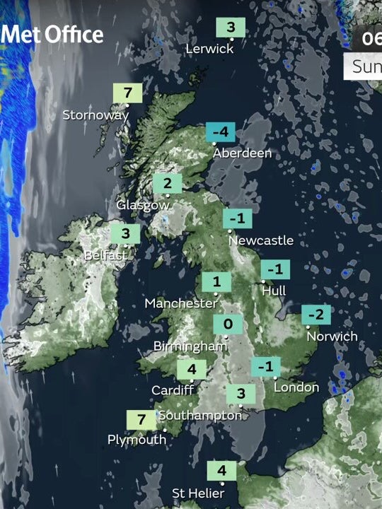
Patches of freezing fog are set to hit parts of the UK after temperatures plummeted to record-lows.
The Met Office says it will be “another very cold and frosty” day as they extended amber alerts until 14 January, meaning a rise in deaths, particularly among the elderly, is likely.
“It’s another very cold and frosty start for many on Sunday morning, with some freezing fog patches in places,” the Met Office said.
“Less cold in the west with patchy rain moving into Northern Ireland.”
The worst affected areas will be in eastern areas of the UK, where temperatures will not climb above three of four degrees Celsius. In the western parts of the UK, temperatures should reach up to nine degrees Celsius.
The forecaster has also issued four flood warnings and 39 flood alerts.
Met Office meteorologist Jonathan Vautrey said: “It is an east-west split in exactly how it feels first thing today. Cold air is still in play across the east to provide a chilly start.
“But further towards the west, southerly winds are starting to bring in something a touch milder.
“The joint factor between east and west, though, is that there are some fog patches around to provide some low visibility.
“Quite dense in places so do take care if you are about to step out or travel at all.
”Once the fog does clear across parts of England and Wales though and into eastern Scotland as well, there will be some sunshine throughout the day to enjoy.”
Those patches of freezing fog should turn cloudier into Sunday night while it is expected to be windier in the north, with rain spreading southwards. Those trends will continue into Monday.
It comes after temperatures plummeted to minus 18.9 degrees Celsius on Saturday morning in Altnaharra, which is in the most northern region of the Highlands and was the UK’s coldest January night in 15 years.
The average low in northern Scotland for this time of year is about 0.3 degrees Celsius.
Join our commenting forum
Join thought-provoking conversations, follow other Independent readers and see their replies
Comments
Bookmark popover
Removed from bookmarks