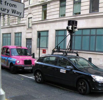
Lost and can't get home...just Google it

The news that the cartographically challenged have been waiting for is here. And it is a gadget that lets you find your way from A to B without ever having to look at a map again. Welcome to the world of Google Street, to be unleashed in Britain this spring.
For the past six months, teams from Google have been driving around London, Manchester, Birmingham and Edinburgh in vans fitted with rooftop 3-D video cameras, taking photos of every street, roundabout and alleyways. And in the new year, all will be uploaded to the internet allowing users, for the first time, to plot routes and work out directions in major cities using 360-degree vision at street-level. The service is already available in Paris, Sydney, Houston, Seville and Rome, Australia, New Zealand, Japan and South America. But because of the poor light and grim weather conditions common to many British cities, many of the photos taken by the Google vans were not clear enough for use on Google Street. So many locations had to be revisited and rephotographed.
The new service is revolutionary: the satellite navigation systems used in cars show road outlines, but the new Google service will show full detail of buildings, streets, and amenities, right down to car wing-mirrors and the blurred faces of people. It opens the prospect of mobile phone users discovering their whereabouts and getting directions on a portable screen, albeit not in real time; the images will generally be two or three months out of date.
A list of practical and business uses for Google Street is not hard to manufacture. The tourism industry expects to profit from previews of famous sites, as holidaymakers get a taste of their vacations before setting a foot out of their doors. Prospective property owners can examine the surroundings of their new homes, and businesses and news organisations can embed images on their websites. Geography teachers in France are even using Google Street to explore big cities with their students.
Google, which is worth $94bn even though its value has more than halved since last December, is sensitive to growing privacy concerns surrounding the internet. Just this week, the Campaign Against a Surveillance Society, a pressure group in Tokyo, wrote to Google Japan to complain after several men were "spotted" entering "love hotels", otherwise known as brothels, in the notorious Shibuya district.
The American firm insists technology automatically blurs faces and licence plates, and says because the images are always a few months out of date, even if a person is identifiable by their clothes their whereabouts at any particular time cannot be known.
Join our commenting forum
Join thought-provoking conversations, follow other Independent readers and see their replies
Comments
Bookmark popover
Removed from bookmarks