Mapped: Charting path of deadly ‘bomb cyclone’ in Pacific Northwest and California
Storm system is expected to weaken as it continues to chart a path over the Cascades and through to northern California and southwest Oregon by Friday
Your support helps us to tell the story
From reproductive rights to climate change to Big Tech, The Independent is on the ground when the story is developing. Whether it's investigating the financials of Elon Musk's pro-Trump PAC or producing our latest documentary, 'The A Word', which shines a light on the American women fighting for reproductive rights, we know how important it is to parse out the facts from the messaging.
At such a critical moment in US history, we need reporters on the ground. Your donation allows us to keep sending journalists to speak to both sides of the story.
The Independent is trusted by Americans across the entire political spectrum. And unlike many other quality news outlets, we choose not to lock Americans out of our reporting and analysis with paywalls. We believe quality journalism should be available to everyone, paid for by those who can afford it.
Your support makes all the difference.A historic “bomb cyclone” has caused multiple deaths and mass power outages after slamming into Seattle, Washington, as it charts a destructive path through California and Oregon.
The extreme weather event brought damaging winds, rainfall and flash flooding that killed at least two people, downed trees and power lines, and left hundreds of thousands without power, after it hit the Evergreen State on Tuesday night.
In Lynnwood, a woman in her fifties was killed when a large tree fell on a homeless encampment, South County Fire said on Tuesday. Another woman was killed by a fallen tree while showering in her King County home, the Bellevue Fire Department said Wednesday.
As of Thursday around noon, more than 300,000 homeowners and businesses in Washington were without power, with King and Snohomish counties the worst impacted areas, according to PowerOutages.us.
An additional 11,000 energy customers have been left in blackout conditions in northern California.

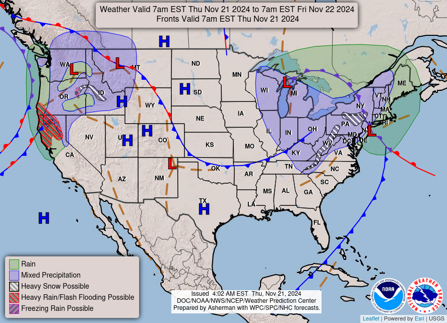
Heavy rains and strengthening winds battered the Bay Area on Tuesday night, with the winter storm reaching maximum intensity on Wednesday, the Weather Prediction Center announced.
Bruising winds with speeds surpassing 77mph wreaked havoc in the western Washington on Wednesday with high surf along the Pacific Northwest coastline throughout the day.
A waterspout spawned in Tokeland in the afternoon as it approached North Cove, after the National Weather Service issued a tornado warning for the area.
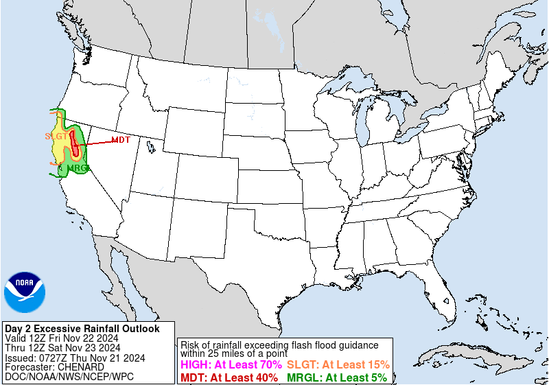
Heavy rains and a “significant” atmospheric river – a large, narrow band of moisture – continued to move slowly over northern California on Thursday morning. The regions are expected to be doused with up to 16 inches of rain by Friday evening.

The WPC has also warned of life-threatening flash flooding and rock slides through the Golden State, with rainfall expected to peak on Thursday and more than a month’s worth of precipitation forecast to fall heading into the weekend.
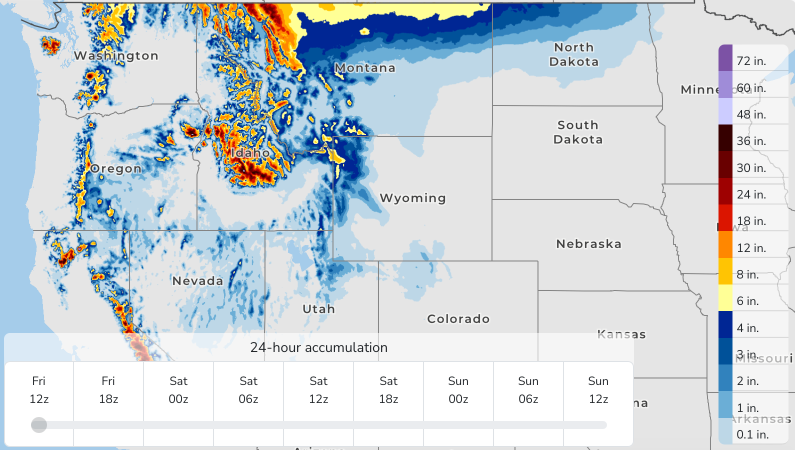
The Cascades and the northmost parts of California will continue to see heavy snowfall, which, combined with 60mph-plus winds, could result in blizzard conditions, forecasters warn.
Heavy rain and snow is due to persist for parts of Northern California and northern Rockies through Friday.
Friday is also expected to bring the heaviest rainfall for areas south of San Francisco.

The storm system is then predicted to weaken as it continues to chart a path through to northern California and southwest Oregon by Friday.
The “anomalously strong” storm system was considered a “bomb cyclone,” which occurs when a cyclone intensifies rapidly.
Another, albeit weaker, bomb cyclone may develop and rapidly strengthen just off the West Coast later this week.
Issaquah mayor Mary Lou Pauly described the weather event on Wednesday as “one of the worst windstorms we’ve had in recent memory,” CNN reports.
Join our commenting forum
Join thought-provoking conversations, follow other Independent readers and see their replies
Comments