Mapped: Tracking Hurricane Milton’s path as it heads for Florida
Floridians are preparing for a ‘monster’ second hurricane to slam into the coast in as many weeks after Helene made landfall last month
Your support helps us to tell the story
Our mission is to deliver unbiased, fact-based reporting that holds power to account and exposes the truth.
Whether $5 or $50, every contribution counts.
Support us to deliver journalism without an agenda.

Louise Thomas
Editor
Hurricane Milton is expected to make landfall in Florida’s Gulf coast on Wednesday bringing devastating winds, life-threatening storm surge and flash floods to communities already battered by Hurricane Helene.
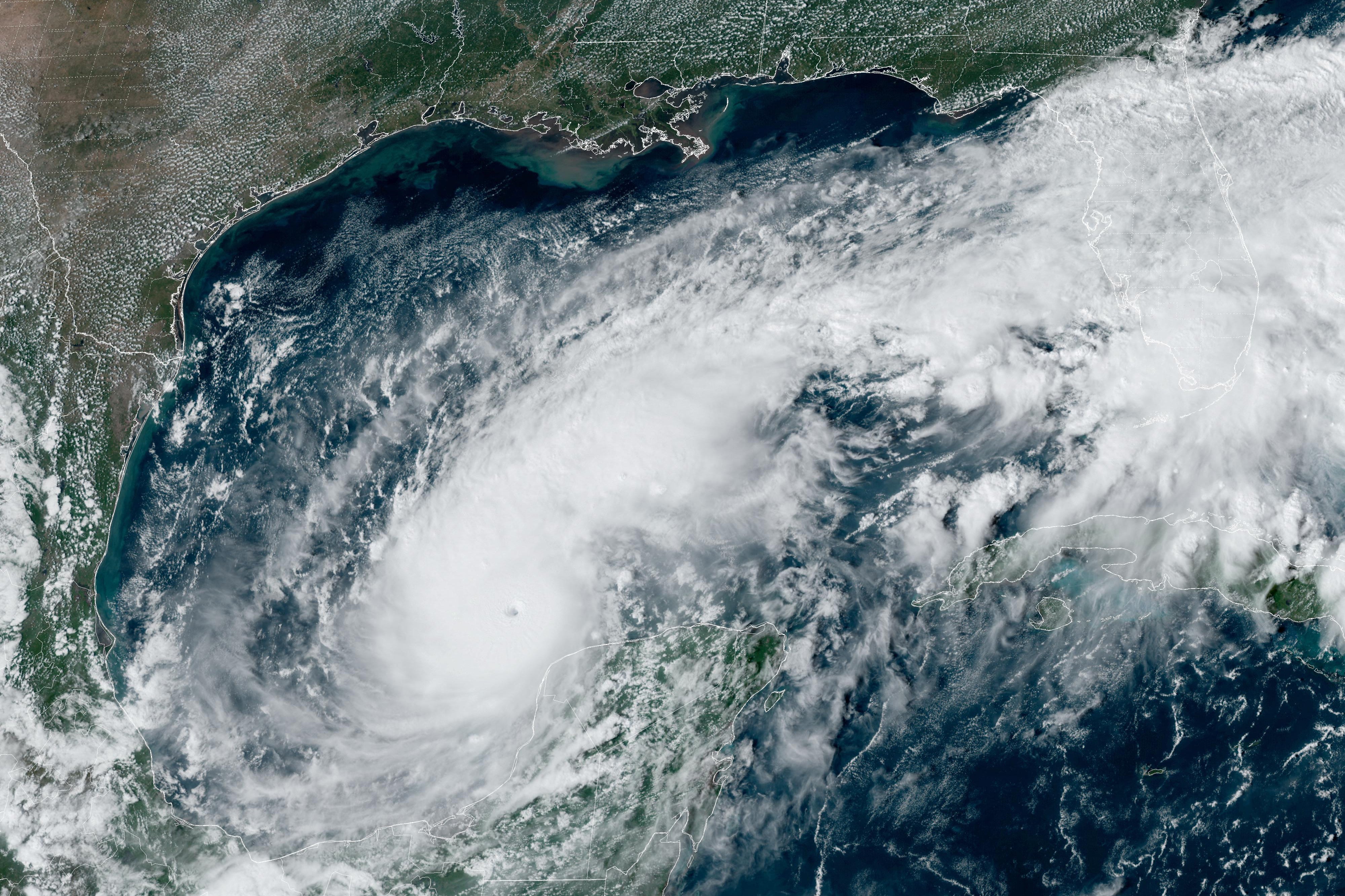
Milton rapidly intensified from a Category 1 to a Category 5 hurricane on Monday with sustained winds surpassing a brutal 180mph, before slowing to Category 4 on Tuesday morning, the National Hurricane Center announced.
Wind speeds grew approximately 90mph in under 24 hours, making it one of the most rapidly intensifying and strongest Atlantic storms ever recorded.
The hurricane comes less than two weeks after Hurricane Helene slammed into Florida’s Big Bend, killing more than 220 and causing hundreds of billions of dollars worth of damage across the Southeast.
With recovery efforts still ongoing, Floridians are now bracing for the new “extremely powerful” storm which, as of Tuesday morning, is tracking towards the northwest and is situated just North of the Yucatan Peninsula.
Milton is then expected to make landfall in the heavily-populated Tampa Bay on Wednesday evening, before charting a path through Orlando. It is expected to grow in size, but wind speeds are anticipated to fall, according to NHC director Dr Michael Brennan.
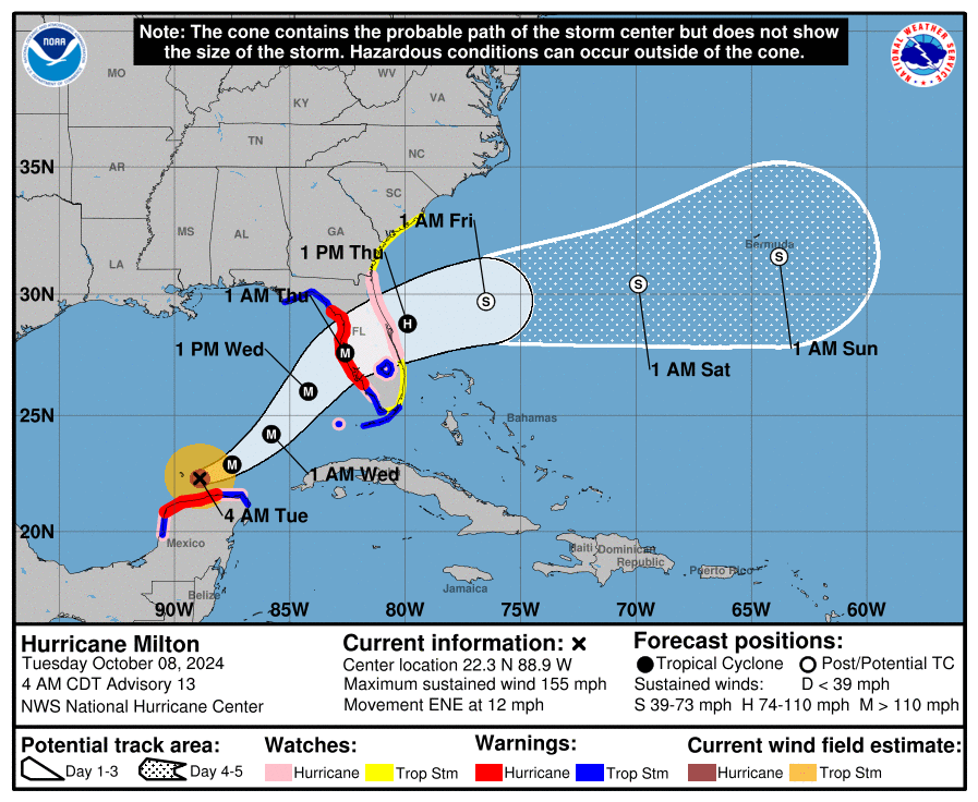
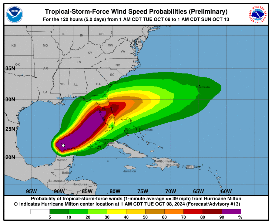
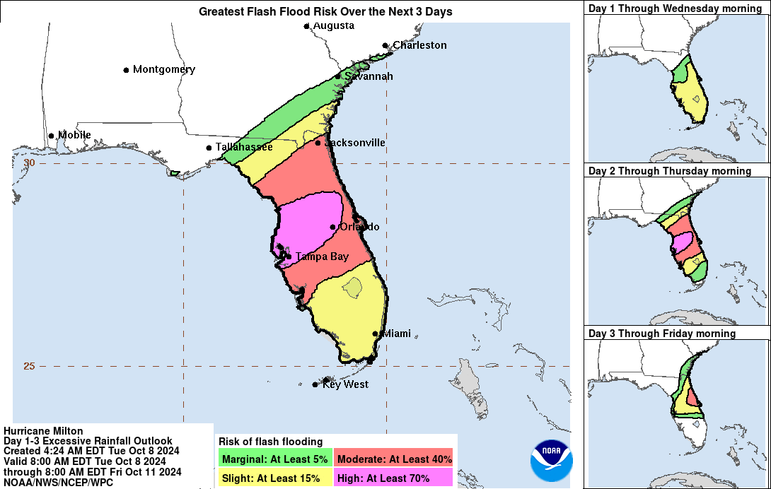
Up to 18 inches of rainfall is expected to be dumped across portions of the Sunshine State’s peninsula and the Florida Keys through to Wednesday evening, with heavy downpours forecast to cause “considerable” and “life-threatening” flash floods, the NHC warned.
Much of Florida’s west coast from the south up to the Big Bend region was under a storm surge watch on Tuesday morning, with peak surge predicted to reach up to 15 feet in Tampa Bay and the Anclote River.
Floridians have been urged to brace for what Kevin Guthrie, director of the Florida Division of Emergency Management, warned could be the largest evacuation since 2017’s Hurricane Irma. “I highly encourage you to evacuate,” Guthrie said.
Tampa Mayor Jane Castor told CNN on Monday that if residents choose to “stay in one of those evacuation areas, you’re gonna die”.
Officials urged residents to strictly follow evacution orders while President Joe Biden approved an emergency declaration on Monday after pledging “life-saving resources in advance of the storm” the day prior.

Florida Governor Ron DeSantis announced Monday that the state has stocked up on millions of gallons worth of fuel, truckloads of food, water and medical supplies, Starlinks and flood protection systems to safeguard “critical infrastructure”.
He said that 4,000 members of the National Guard had been deployed to the state, with all hands on deck to clear debris from Helene in preparation for Milton amid fears that existing wreckage could “increase damage dramatically.”
AccuWeather lead hurricane expert Alex DaSilva warned that debris from Helene could “turn into airborne missiles or be swept away in flooding and storm surge”.
The weather forecasting company’s chief meteorologist Jonathan Porter described Milton as a “once-in-a-lifetime storm for Floridians”.
Subscribe to Independent Premium to bookmark this article
Want to bookmark your favourite articles and stories to read or reference later? Start your Independent Premium subscription today.
Join our commenting forum
Join thought-provoking conversations, follow other Independent readers and see their replies
Comments