Tropical wave threatens Florida with its first hurricane in more than a decade
If the storm system in the Caribbean turns into Hurricane Hermine, forecasters fear it could also strike Louisiana, which is already recovering from catastrophic floods that left 13 dead

Your support helps us to tell the story
From reproductive rights to climate change to Big Tech, The Independent is on the ground when the story is developing. Whether it's investigating the financials of Elon Musk's pro-Trump PAC or producing our latest documentary, 'The A Word', which shines a light on the American women fighting for reproductive rights, we know how important it is to parse out the facts from the messaging.
At such a critical moment in US history, we need reporters on the ground. Your donation allows us to keep sending journalists to speak to both sides of the story.
The Independent is trusted by Americans across the entire political spectrum. And unlike many other quality news outlets, we choose not to lock Americans out of our reporting and analysis with paywalls. We believe quality journalism should be available to everyone, paid for by those who can afford it.
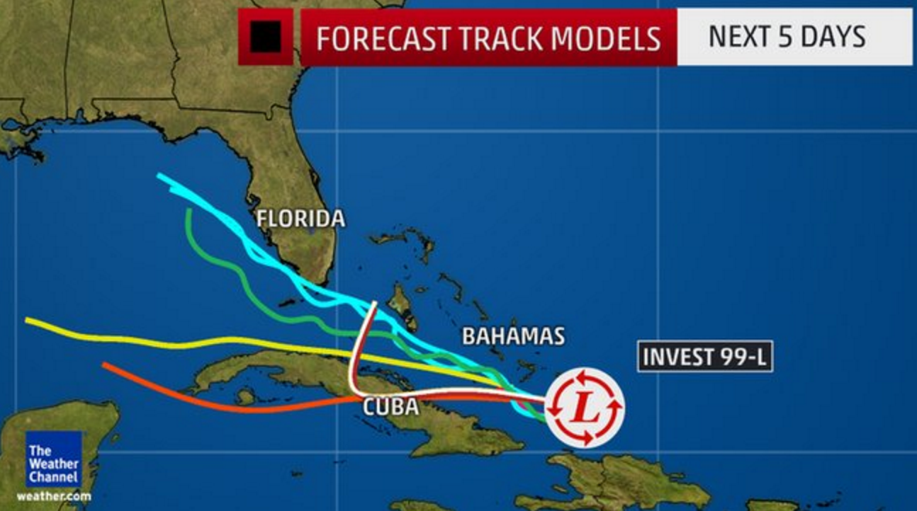
Your support makes all the difference.A tropical wave in the Atlantic could turn into the first Hurricane to strike Florida in more than 10 years, before crossing the Gulf of Mexico to deluge Louisiana, which is still in the early stages of recovery from catastrophic recent floods.
The storm, which was situated in the Caribbean southeast of the Turks and Caicos Islands on Thursday morning, remains ill-defined and disorganised with no obvious centre, forecasters said. But the National Hurricane Centre said the system, currently known as Invest 99-L, had a 60 per cent chance of developing into a named storm in the next two days, and an 80 per cent chance over the next five days.
That would make it Hurricane Hermine, the eighth named storm of the 2016 Atlantic Hurricane Season, which runs from June to November. The last storm of such force to hit Florida was Hurricane Wilma in October 2005, the state’s longest storm drought on record.
In the eleven years since Wilma, the state’s population has ballooned to more than 20 million, leaving many people and new infrastructure exposed to the dangers of a major storm. On Thursday, water managers in South Florida began preparing pumps and canals for flood control, the Miami Herald reported.
The storm, which would likely reach South Florida late on Sunday, would also bring with it a threat of more mosquitoes, days after state officials announced five new Zika cases in Miami, bring the total number of cases of the virus in Florida to 42.
If the storm hits Florida, it could continue west and make a second landfall on the Gulf Coast next week: troubling news for Louisiana, which suffered devastating floods beginning on 11 August, leaving 13 people dead and tens of thousands displaced. With the ground already saturated, the region “could quickly experience flooding again,” a meteorologist for the National Weather Service in New Orleans told USA Today.
On the other hand, the system could dissipate and reach Florida only as a minor storm, or even veer away from the US coastline altogether. Forecasters have warned, however, that parts of the Caribbean – including Hispianola, Haiti, the Turks and Caicos and central Bahamas – should prepare for heavy rain and winds that could cause floods and landslides over the next 48 hours.
Join our commenting forum
Join thought-provoking conversations, follow other Independent readers and see their replies
Comments