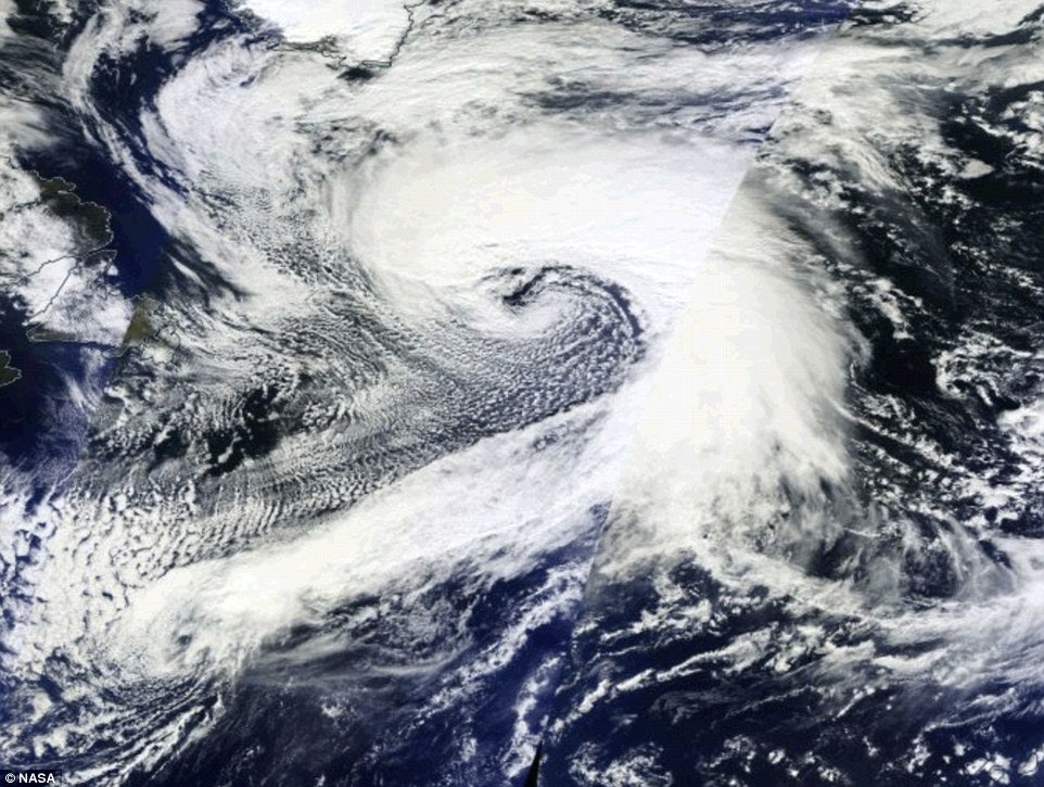
UK weather: Storm system set to bring wet, windy and warm weather this weekend
Spectacular storm system will bring wet and windy weather

Your support helps us to tell the story
From reproductive rights to climate change to Big Tech, The Independent is on the ground when the story is developing. Whether it's investigating the financials of Elon Musk's pro-Trump PAC or producing our latest documentary, 'The A Word', which shines a light on the American women fighting for reproductive rights, we know how important it is to parse out the facts from the messaging.
At such a critical moment in US history, we need reporters on the ground. Your donation allows us to keep sending journalists to speak to both sides of the story.
The Independent is trusted by Americans across the entire political spectrum. And unlike many other quality news outlets, we choose not to lock Americans out of our reporting and analysis with paywalls. We believe quality journalism should be available to everyone, paid for by those who can afford it.
Your support makes all the difference.A spectacular storm system that developed across the Atlantic earlier this week is heading towards the UK and Europe and is likely to bring with it high winds and heavy rain continuing Britain's topsy-turvy spell of Autumn weather.
While some areas in the UK are expecting so-called 'Indian Summer' conditions, with temperatures on Friday expected to peak at around 21C, other areas look likely to experience a washout with between fifteen to 25mm of rain falling.
A few places could even see in excess of 40mm of rain at times over the next few days, forecasters said.
Meanwhile, across the Atlantic the enormous storm system intensified early on Monday with its central pressure dropping 46 mb in 24 hours - from 1002 mb to 956 mb.
Known as a meteorological or weather bomb the massive storm system rapidly developed hurricane strength winds which reached Category 3 on the Saffir–Simpson hurricane wind scale.
According to the Washington Post and the NOAA NWS Ocean Prediction Centre the storm developed winds of 130mph south of its centre and may well have caused waves of up to 40 feet.
After reaching its peak on Monday the storm's intensity has gradually reduced and the system will be significantly weakened by the time it passes over the UK and Europe this weekend.
Despite this weakening, forecasters are still predicting the system will dump heavy rainfall on the South East, the Midlands and parts of East Anglia over the next few days.
Although it is likely to bring wet and windy weather the storm system will also bring with it unseasonably warm conditions, with some areas of Britain being hotter than Spain.
Some forecasters have predicted that 65mm of rain could fall on parts of Cornwall over the next five days - with similar amounts possible in Cumbria and South Wales.
In a blog on their website the Met Office said that while the weather system was large it wasn't particularly intense, powerful or unusual, but that it would lead to continued unsettled weather across many parts through Friday.
"While it may look impressive on the charts – it’s not going to bring anything out of the ordinary for the UK over the next few days", the forecaster said.
"It will, however, be generally unsettled across many parts through Friday and the weekend, as the low pressure drives a weather system across the UK."
"This will bring strong winds, with gusts of up to 50mph in the most exposed parts of the west, and rain in places. However, some parts will enjoy periods of drier and brighter weather."
The Environment Agency currently has six flood warnings in place for areas across the South East, the Midlands and Anglia regions.
A forecaster for Meteogroup said: "Today, a band of rain stretching from Northern Ireland, through northern and eastern parts of England will continue to drift northwards overnight, reaching all but northern Scotland by dawn."
"Tomorrow, lingering rain across northern parts of the UK will tend to die out through the day with the best of the sunshine reserved for north-west Scotland. The southern half of the UK will have a mild day with sunny intervals and scattered showers."
"The showers are expected to be heaviest and most frequent in south Wales and south-west England during the afternoon when they may turn thundery."
"On Friday, many areas will be dry and fairly warm with some sunshine, although a few showers are possible in the west. Turning increasingly wet and windy in the west during the evening. On Saturday, rain will give way to sunshine and heavy showers. Remaining very mild for mid-October."
Join our commenting forum
Join thought-provoking conversations, follow other Independent readers and see their replies
Comments