Storm Lilian set to bring heavy rain and winds before bank holiday weekend
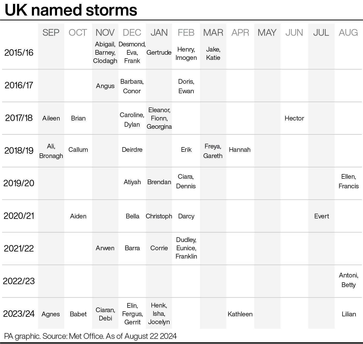
Lilian is the twelfth named storm of the season – the furthest the Met Office have got through the list since it was introduced

Your support helps us to tell the story
From reproductive rights to climate change to Big Tech, The Independent is on the ground when the story is developing. Whether it's investigating the financials of Elon Musk's pro-Trump PAC or producing our latest documentary, 'The A Word', which shines a light on the American women fighting for reproductive rights, we know how important it is to parse out the facts from the messaging.
At such a critical moment in US history, we need reporters on the ground. Your donation allows us to keep sending journalists to speak to both sides of the story.
The Independent is trusted by Americans across the entire political spectrum. And unlike many other quality news outlets, we choose not to lock Americans out of our reporting and analysis with paywalls. We believe quality journalism should be available to everyone, paid for by those who can afford it.
Your support makes all the difference.A storm is set to smash parts of the country with heavy rain and strong winds as millions prepare getaways for the bank holiday weekend.
Storm Lilian, announced by the Met Office on Thursday, could bring gusts of up to 80mph – with travel disruption, flooding, power cuts and dangerous conditions near coastal areas all likely.
The forecaster has issued two new yellow weather warnings for rain in south-west Scotland and the Aberdeenshire coast from 9pm on Thursday to 9am Friday.
For the latest updates on this developing weather story, follow The Independent’s live coverage
There is the possibility of thunder, while 20-30mm of rainfall is expected widely across both areas – with a chance of 40-50mm over higher ground.

A yellow wind warning has also been issued covering northern England and north Wales from 5am to 11am on Friday, with the storm widely expected to bring gusts of 50-60mph in the region.
It comes after large parts of Scotland and northern England faced heavy rain and strong winds on Wednesday.
Two yellow winds warnings covering northern Wales and northern England, including both Cumbria and Northumberland, were already in place on Thursday morning.
Met Office spokesman Stephen Dixon said: “Storm Lillian is an area of low pressure which is going to be drifting towards the UK from the west and bringing some strong winds and some heavy rain in the early hours of Friday and through Friday morning as well.”
Lilian is the 12th named storm of the season – the furthest the Met Office have got through the list since it was introduced – and the first since April.

Storms are named when they have the potential to cause disruption or damage which could result in an amber or red warning, the Met Office said.
This is primarily based on impacts from strong winds but other weather types will also be considered, including rain if flood warnings are advised by national agencies, or snow.
Mr Dixon said: “Take steps to do what you can do to protect your property and people from injury, so checking for loose items around your home and planning how to secure them down, whether that’s bins, garden furniture or trampolines, and checking travel plans before you head out if you’re within those warning areas to avoid delays – and amending any plans as needed.
“Gathering torches, batteries and power packs for mobile phones can be useful things to do to prepare for power cuts.”
Lillian’s influence will “wane” by Friday afternoon as it reduces in intensity and pushes off into the North Sea, with scattered showers for most for the rest of the day, Mr Dixon said.

After the possibility of some heavy showers early on Saturday, settled conditions are likely to develop across southern and eastern England and Wales with sunny spells and dry conditions mixed with the odd chance of scattered showers.
The North and North West will continue to see “a fairly unsettled weekend”, with various fronts moving in and bringing more persistent rain, particularly for parts of western Scotland and Northern Ireland, the forecaster said.
Temperatures will reach highs of 21C on Saturday and Sunday and 23C on Monday in the South East, slightly below average for the time of year.
A New Order music concert due to take place in Cardiff on Thursday has been cancelled, with organisers citing the “severe winds” and a bad weather forecast.
Attendees at the sold-out Reading & Leeds festivals taking place over the weekend are likely to avoid the worst of any of the conditions.

The RAC estimated that 19.2 million leisure trips by car will be made over the weekend, with 3.2 million on Friday alone.
This is highest since the motoring services company began recording data for the summer bank holiday in 2015.
RAC Breakdown spokesperson Alice Simpson said the adverse weather and large volume of expected trips represented “a perfect storm” for drivers.
She said: “Anyone driving in areas impacted by Storm Lilian should try to avoid exposed coasts and higher routes where there’s a greater chance of fallen branches and trees. It’s vital to lower your speeds and leave plenty of extra stopping distance to allow yourself time to react quickly.
“Drivers should keep a firm grip on the steering wheel and take extra care when passing high-sided vehicles which can cause an unnerving buffeting effect when you’re suddenly hit by the wind on the other side.”