Death toll from weekend storms rises again after 140mph tornadoes and wildfires - and there is more bad weather on the way
At least seven states have been affected after tornadoes struck over the weekend
At least 42 people have died after a swathe of tornadoes tore across seven Midwest and Southern U.S. states - and there is more bad weather on the way.
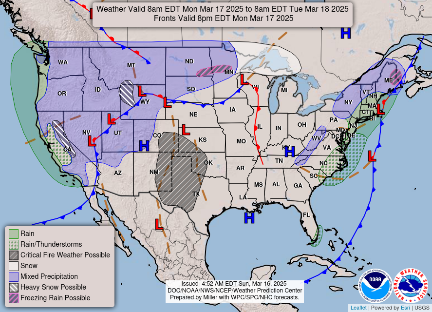
The National Weather Service announced Sunday that a fresh new Pacific storm would rip across the West on Monday and Tuesday towards Utah, Wyoming, South Dakota, and Nevada, through to Washington, bringing “heavy mountain snow, gusty to high winds, and lower elevation rain”.
It comes after storms destroyed homes and triggered blackouts for tens of thousands of people in the Mississippi Valley and Deep South over the weekend.
A dozen people have died in Missouri, three in Alabama, eight in Kansas, six in Mississippi, four in Texas, three in Arkansas, and four in Oklahoma, according to multiple officials to ABC News.
Below we look at what warnings and alerts are still in place.
Tampa, Florida
On Monday morning, the National Weather Service in Tampa Bay issued a red flag warning in effect from noon to 8 p.m. EDT across several parts of west-central and southwest Florida.
Areas affected by the warning include Sumter, Polk, Hardee, Highlands, DeSoto, Inland Citrus, Inland Hernando, Inland Pasco, Inland Hillsborough, Inland Manatee, Inland Sarasota, Inland Charlotte, and Inland Lee.
Northwesterly winds of around 10 to 20 mph, gusting 30 mph, are anticipated, and the weather service warned that any fire that develops “will catch and spread quickly.”
W. Virginia, Ohio, and Pennsylvania
A new tornado watch was issued Sunday for east central Ohio, southwest Pennsylvania, and the northern panhandle of West Virginia, according to the National Weather Service.
Officials warned the threat would be ramping up over the course of the day – from 10:30 a.m. to 4:00 p.m.
The warning has since expired as Americans woke up to the damage caused overnight.
As the storms ripped across the Susquehanna Valley, almost 60,000 have been left without power in Pennsylvania and over 20,000 in New York state, as of Monday morning according to poweroutage.us.
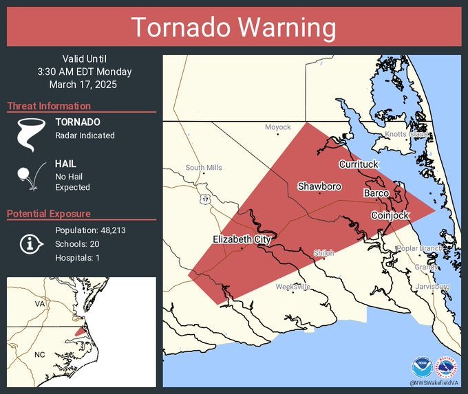
The Carolinas
As of Monday morning, a tornado warning was still active for Elizabeth City, Camden, and Coinjock in North Carolina – until 3:30 a.m. EDT. A flood warning is now also in effect through until early Wednesday morning.
On Sunday evening, the weather service warned that damaging winds and “a few tornadoes” remained possible across parts of the Mid-Atlantic and the Southeast.
Earlier that day, roughly 250,000 Americans were without power, according to poweroutage.us.
Tornado watches were still in effect Sunday morning in counties across North and South Carolina through Sunday afternoon, according to the National Weather Service. Strong winds are expected to whip throughout the day Sunday into the evening, with gusts of up to 45 mph.
A U.S. National Weather Service survey team declared that an EF-1 tornado struck the Chapin-Lake Murray area with winds hitting around 90 mph Sunday morning, as per WSOC-TV.
Texas
A critical fire weather warning remains across parts of western North and Central Texas for most of the day Monday through to the evening. A Red Flag warning is in effect from 11 a.m. through 10 p.m.
Deadly wind gusts will climb to 35 mph across the warned areas and parts east of the I-35 corridor “will see elevated fire weather conditions” with rain and wind gusts hitting 25 to 30 mph.
The Texas Department of Public Safety reported three deaths in three separate car crashes due to low visibility and high winds after a dust storm ripped through the state Friday. Another three people also died in Arkansas amid the storms.
The Independent contacted the NOAA for further updates.
Join our commenting forum
Join thought-provoking conversations, follow other Independent readers and see their replies
4Comments