Threat of floods as gales set to give Britain a battering

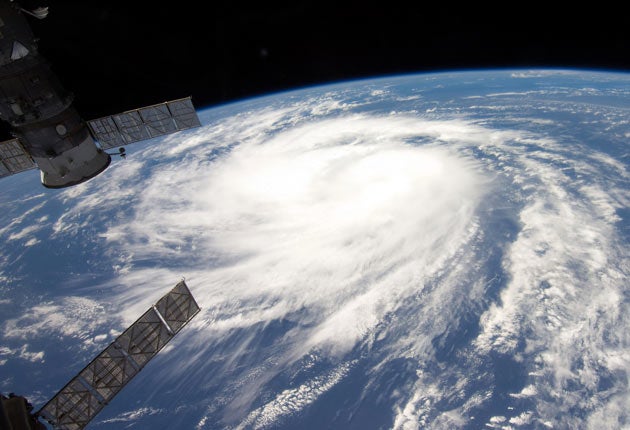
Britain is set to be hit by gale force winds of up to 80mph over the next few days, bringing a real threat of flooding. Hurricane Katia, currently veering across the Atlantic towards the UK from the Caribbean, threatens to leave a trail of destruction in its wake when it finally arrives.
Katia failed to make landfall in the US, but nonetheless, forecasters are warning of structural damage, travel delays and fallen trees in the UK. The first of the big winds could hit as early as tomorrow night and severe weather warnings have already been issued along the entire western and south-western coasts.
The most exposed areas could see waves of up to 50ft, while the predicted high winds could also coincide with high tides leading to localised flooding – although experts played down comparisons to the Great Storm of 1987 in which 18 people died.
However, the Met Office admitted that it could be hard to predict where and when the deep, slow-moving depression will reach these shores and advised people to keep up to date with the changing forecast if they were travelling. As it sweeps northwards Katia is expected to lose its tropical character, arriving in the UK as an Atlantic gale, or typical winter storm.
Yesterday the Met Office issued a "yellow" alert, telling people to be aware of the risk of a "high-impact" weather system.
Eddie Carroll, chief forecaster at the Met Office, said: "Although it will be very windy everywhere, it is uncertain as to exactly which parts of the country will see the very strongest winds."
The very windy weather is expected to ease by the middle of the week, although it will remain blustery, continuing what has been a wet start to the autumn after the coolest summer for 18 years.
Britain is often on the receiving end of tropical storms at this time of year. The last to cause serious damage were Hurricanes Bill and Grace which resulted in gales in 2009.
The last full-blown hurricane to hit the British Isles was Hurricane Charley in 1986, which deposited more than eight inches of rain over parts of southern Ireland and washed out the August Bank Holiday.
Katia is the second major storm of the hurricane season and was rated as a category four at its peak.
Join our commenting forum
Join thought-provoking conversations, follow other Independent readers and see their replies
Comments
Bookmark popover
Removed from bookmarks