New tsunami map shows how San Francisco could be devastated
‘We are preparing for a worst-case scenario. A 9.3 magnitude quake off Alaska, that would be the worst-case for San Francisco’
Your support helps us to tell the story
From reproductive rights to climate change to Big Tech, The Independent is on the ground when the story is developing. Whether it's investigating the financials of Elon Musk's pro-Trump PAC or producing our latest documentary, 'The A Word', which shines a light on the American women fighting for reproductive rights, we know how important it is to parse out the facts from the messaging.
At such a critical moment in US history, we need reporters on the ground. Your donation allows us to keep sending journalists to speak to both sides of the story.
The Independent is trusted by Americans across the entire political spectrum. And unlike many other quality news outlets, we choose not to lock Americans out of our reporting and analysis with paywalls. We believe quality journalism should be available to everyone, paid for by those who can afford it.
Your support makes all the difference.The Bay Area is no stranger to preparing for natural disasters, but California state geologists are now warning that a tsunami could be more devastating than previously believed.
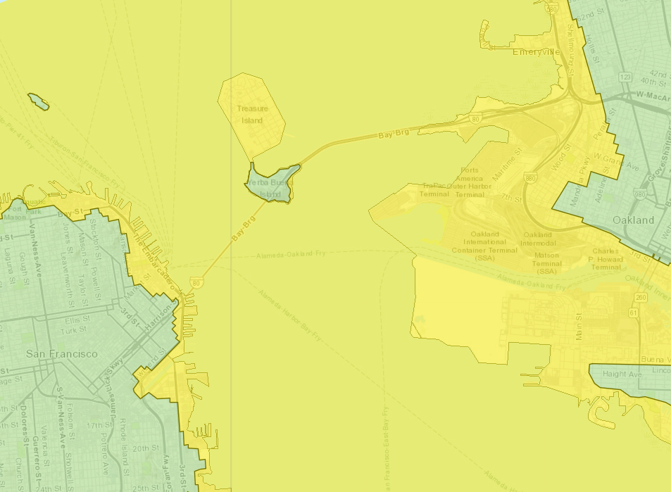
New interactive hazard maps released online provide an updated look at just how much of the region could be inundated were a major once-in-a-lifetime catastrophe to strike.
The California Geological Survey used new technology to update its tsunami maps for the first time since 2009, since when scientists have been able to study the lessons learned from the Japanese tsunami of 2011.
“We are preparing for a worst-case scenario. A 9.3 magnitude quake off Alaska, that would be the worst-case for San Francisco,” Adrienne Bechelli, deputy director of San Francisco’s Department of Emergency Management. told ABC7.
A tsunami triggered by a large earthquake in Alaska would take approximately five hours to reach the city.
The impact on downtown San Francisco is worse than first thought. It was previously assumed that areas that are immediately adjacent to the water such as the Fisherman’s Wharf, the Embarcadero, and the area around the famous Ferry Building would receive the brunt of any wave.
However, the new maps show water potentially surging into parts of North Beach and the Financial District as far as Fremont Street.
The same is true across the region with waves hitting West Oakland and Lake Merritt. The entire Oakland Container Terminal and the city’s international airport would be inundated.
Tsunami evacuation routes, already signposted throughout the Bay Area will now have to be updated.
"Bottom line: If you’re near the coast and feel strong shaking from a local earthquake or get an official notification to evacuate, move inland or to a higher elevation as soon as possible,” says Rick Wilson, head of the CGS Tsunami Program. “A large tsunami surge might be fascinating to watch but you don’t want to be anywhere near it.”
Officials continue to urge people to have a plan and sign up for emergency alerts.
The tsunami triggered by the 2011 Japan earthquake rippled across the entire Pacific Ocean wreaking havoc in Santa Cruz harbour to the south of San Francisco, leaving heavy damage. Approximately $100m in damage occurred up and down the coast.
More than 150 tsunamis have hit California’s shore since 1800. Most were barely noticeable, but a few have caused fatalities or significant damage.
The most destructive tsunami to hit California occurred on 28 March 1964. Several surges reaching 21 feet high swept into Crescent City four hours after a magnitude 9.2 earthquake in Alaska, killing 12 and levelling much of the town’s business district.
Join our commenting forum
Join thought-provoking conversations, follow other Independent readers and see their replies
Comments