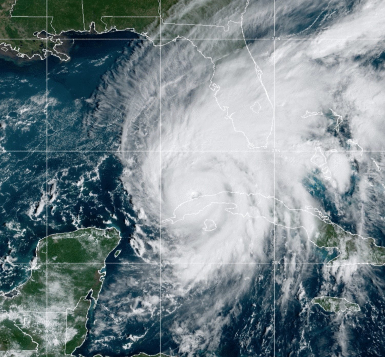
Satellite images reveal monstrous Category 3 Hurricane Ian from space
The storm was passing over western Cuba on Tuesday and is expected to further strengthen before hitting Florida
Your support helps us to tell the story
From reproductive rights to climate change to Big Tech, The Independent is on the ground when the story is developing. Whether it's investigating the financials of Elon Musk's pro-Trump PAC or producing our latest documentary, 'The A Word', which shines a light on the American women fighting for reproductive rights, we know how important it is to parse out the facts from the messaging.
At such a critical moment in US history, we need reporters on the ground. Your donation allows us to keep sending journalists to speak to both sides of the story.
The Independent is trusted by Americans across the entire political spectrum. And unlike many other quality news outlets, we choose not to lock Americans out of our reporting and analysis with paywalls. We believe quality journalism should be available to everyone, paid for by those who can afford it.
Your support makes all the difference.Satellites are capturing the enormous Hurricane Ian from space as the Category 3 storm barrels towards the Florida coast.
The images, released by the US National Oceanic and Atmospheric Administration (NOAA), showed tightly packed storm bands rotating north as the eye passed over western Cuba on Tuesday morning.
As of midday Tuesday (EST), the storm was moving at 10mph over Havana in the direction of Key West with maximum sustained winds of about 115mph.
Cuba was lashed with heavy rain and winds overnight, bringing the threat of coastal surges, flash flooding and landslides.
Meteorologist Brandon Orr, from WPLG in Miami, tweeted video shortly before midday on Tuesday showing water already pouring over the sea wall in Key West. The region is expected to have storm surge between two and four feet, and winds up to 70mph.
The most recent weather models have the hurricane projected to make landfall south of Tampa Bay but the size of the storm, which is being supercharged by warm waters in the Gulf, means that large stretches of Florida’s west coast are also at-risk.
On Tuesday, Governor Ron DeSantis urged Floridians to heed warnings to evacuate and seek higher ground due to potential for “‘catastrophic flooding and life-threatening storm surge”.
New hurricane watches and warnings were also being issued for neighboring states of Georgia and South Carolina on Tuesday.
As the climate crisis drives up the world’s average ocean and air temperatures, hurricanes are expected to become stronger — and the damage more catastrophic, scientists say.
Join our commenting forum
Join thought-provoking conversations, follow other Independent readers and see their replies
Comments