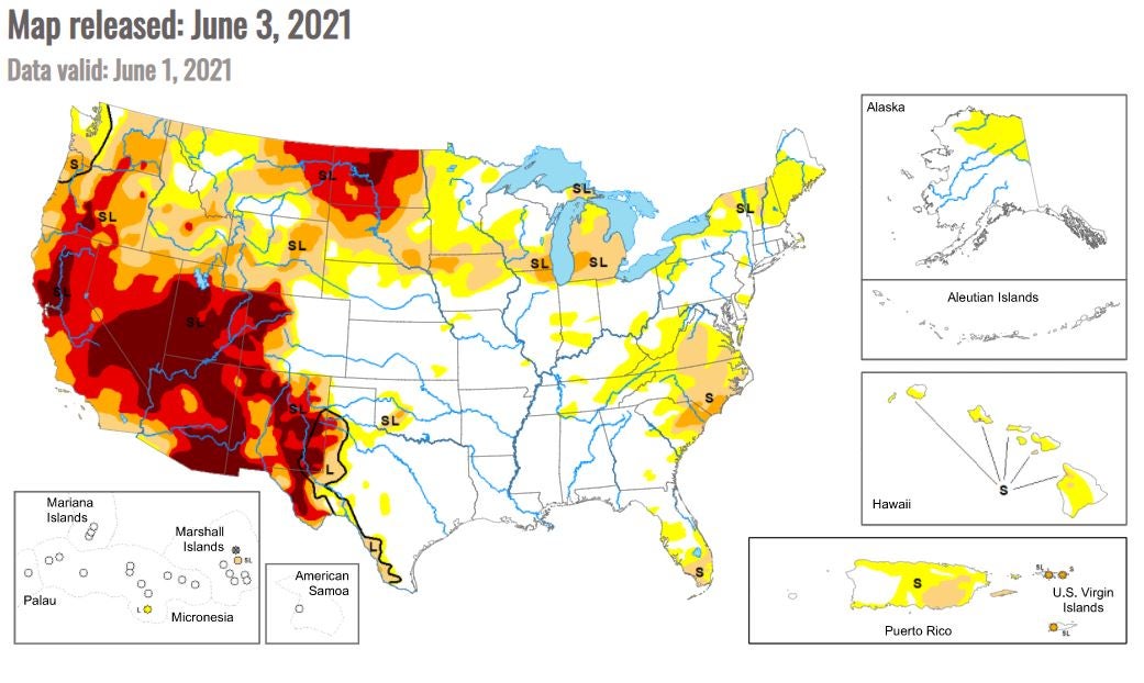
Graphic reveals troubling level of US drought this year
The area stricken by drought has more than doubled since last year

Your support helps us to tell the story
From reproductive rights to climate change to Big Tech, The Independent is on the ground when the story is developing. Whether it's investigating the financials of Elon Musk's pro-Trump PAC or producing our latest documentary, 'The A Word', which shines a light on the American women fighting for reproductive rights, we know how important it is to parse out the facts from the messaging.
At such a critical moment in US history, we need reporters on the ground. Your donation allows us to keep sending journalists to speak to both sides of the story.
The Independent is trusted by Americans across the entire political spectrum. And unlike many other quality news outlets, we choose not to lock Americans out of our reporting and analysis with paywalls. We believe quality journalism should be available to everyone, paid for by those who can afford it.
Your support makes all the difference.The drought in the western US is worsening, with affected areas facing extreme conditions more than doubling in size.
Data from the National Oceanic and Atmospheric Administration showed that in 2020 – the worst fire season on record – drought conditions reached "severe" status in parts of northern California, central Oregon, Washington, Idaho and Nevada, as well as the northeast quadrant of Utah and a swath of land across the border regions between Colorado and New Mexico. They reached "extreme" status in small parts of northern California, central Oregon, and were most present in southern Colorado.
This year's recordings are alarming.
The NOAA's 2021 data shows that virtually the entirety of the south western US is now under severe drought conditions. Nearly the entirety of Oregon, California, Nevada, Utah, Arizona, and New Mexico are under "extreme" drought conditions, as are parts of Texas and Colorado.
A third designation – "exceptional" – describes drought conditions so extreme that it was not applicable for use in the 2020 map.

In the 2021 data, however, there are huge swaths of "exceptional" drought conditions reported throughout the southwest.
The largest section of "exceptional" drought conditions are centered in the Mojave Desert and the arid regions surrounding it in Utah, Arizona, and Nevada. Approximately half of New Mexico, parts of northwest Colorado, and California's central valley are also under exceptional conditions.
Also new to this year's map is the inclusion of drought-stricken northern states. North east Montana and virtually all of North Dakota and its southern border are experiencing some level of drought.
In 2020, none of these states had drought conditions. Now, almost all of North Dakota is under extreme drought conditions, with the state's central core suffering from exceptional drought.
In addition to throttling US agricultural output from the west, droughts also create the best conditions for wildfires by drying up plants and robbing the soil of moisture that might otherwise mitigate the spread of a blaze.
Hundreds of people were evacuated from their homes in eastern Arizona – which is under extreme and exceptional drought conditions – when a pair of wildfires began to spread across the land. On Sunday officials reported the fires had already consumed 60,000 acres.
The expected drought is so bad that Utah Governor Spencer Cox called on the faithful in his state to pray for water.
The "exceptional" drought regions are taking a major toll on the Colorado River, which supplies water to 40 million people across seven states.
Lake Mead, the reservoir created by the pooling of water at the Hoover Dam, is at only 37 per cent of its capacity. The last time the lake was full was 2000.
Some of the region's most populous regions – Las Vegas, Phoenix, and southern California – rely on the river as a major source of water.
Join our commenting forum
Join thought-provoking conversations, follow other Independent readers and see their replies
Comments