Hurricane Helene accelerates toward Florida’s Big Bend threatening ‘unsurvivable’ storm surge: Live
Hurricane Helene could bring ‘unprecedented damage’ to Florida with sustained winds up to 135mph and 20ft storm surge
Your support helps us to tell the story
My recent work focusing on Latino voters in Arizona has shown me how crucial independent journalism is in giving voice to underrepresented communities.
Your support is what allows us to tell these stories, bringing attention to the issues that are often overlooked. Without your contributions, these voices might not be heard.
Every dollar you give helps us continue to shine a light on these critical issues in the run up to the election and beyond

Eric Garcia
Washington Bureau Chief
Florida is bracing for “unsurvivable” storm surge from Hurricane Helene, a Category 4 storm.
In the afternoon, Helene was accelerating toward Florida’s Big Bend, bringing tropical storm conditions across most of the state’s western coast. Florida, Alabama, and parts of the Carolinas are at risk of flooding.
Just over a month after Storm Debby hurtled into the Sunshine State, Hurricane Helene now threatens to become the strongest storm to hit the US in over a year.
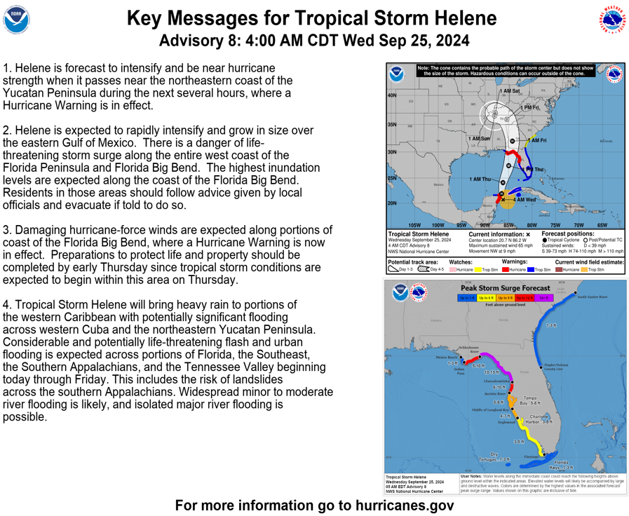
Hurricane Helene has maximum sustained winds of 140mph as of Thursday night. Florida officials are warning residents to brace for life-threatening rain and storm surge. All parts of Florida are under a hurricane or tropical storm warning.
Its size is also massive compared to previous hurricanes in the Gulf of Mexico. Local forecasters estimate the storm stretches 822 miles in width, and 114 in length. Hurricane warnings extend roughly 90 miles above the Georgia-Florida line.
According to The Associated Press, Helene is forecast to be one of the largest storms in breadth to hit the region in years, with only three bigger since 1988.
 Mapped: Charting Hurricane Helene’s path as Florida braces for landfall
 Hurricane Helene threatens ‘unsurvivable’ storm surge and damage, forecasters say
 Watch live: Category 2 Hurricane Helene set to make landfall in Florida
 Disney cruise stuck at sea while Hurricane Helene ripped through the Cayman Islands
What time is Hurricane Helene expected to make landfall?
Helene is expected to be a major hurricane – potentially Category 4 – when it reaches Florida’s Big Bend coast.
It is expected to make landfall at some point on Thursday evening, according to the latest announcement from the National Hurricane Center.
Parts of Florida’s Gulf Coast may experience tropical storm-force winds from the early hours of Thursday morning.
After landfall, the hurricane is expected to turn northwest, slow down as it charts its path over the Tennessee Valley on Friday and into the weekend.
Explainer: What is storm surge?
Storm surge occurs when strong winds push sea water onshore, causing an abnormal rise in water level.
It can result in extensive flooding for those living in coastal areas, with heavy rains and large waves generated from the wind adding to build up of water.
The change in sea level is measured at the height the water sits above the normal predicted astronomical tide.
The National Hurricane Center has declared a “life threatening situation” with much of Florida’s Gulf Coast expected to experience nine-plus feet of storm surge.
The stretch between Carrabelle to Suwannee River in Florida may expect up to 20ft of storm surge, according to the NHC’s latest briefing.
See the National Weather Service’s diagram below:
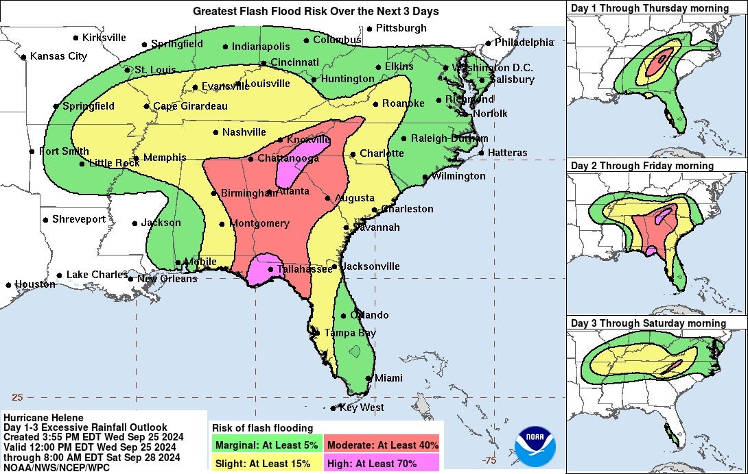
Mapped: Hurricane Helene flash flood risk
Race against time as Floridians ‘rush’ in final preparations to brace ‘catastrophic’ winds and storm surge
State emergency chief warns residents of Helene’s impact
Florida’s emergency chief, Kevin Guthrie, warned the effects of Helene will be far-reaching and residents should be careful even if they think they’re far from the storm.
“Tropical storm force winds can be filled up to 250 miles from the center,” Guthrie explained at a Wednesday morning press conference
“Tornadoes are probable and high winds, life-threatening storm surge and flooding cannot be ruled out,” he added.
Guthrie urged residents to keep their devices on to receive emergency alerts and to have an evacuation plan in place.
Helene to hit Florida two years after devastating Hurricane Ian
Hurricane Helene, which is expected to strengthen to Category 4, will batter Florida two years after Hurricane Ian.
Hurricane Ian made landfall near Cayo Costa, Florida, in September 2022. Meanwhile, Helene is set to make landfall slightly north, near Florida’s Big Bend region.
Hurricane Ian is the costliest to ever hit Florida and the third-costliest in US history.
The Federal Emergency Management Agency has provided $1.15 billion for 387,139 households to assist with home repairs, lodging expenses, rent payments and other needs.
The agency also allocated $2.3 billion to reimburse state, local and tribal governments and nonprofit organizations for storm-related costs.
Hurricane Helene is set to cause ‘unprecedented’ damage to parts of the state.
“We will have countless downed trees. We will have structural damage. We will have loss of power,” Tallahassee Mayor John Dailey said on Wednesday. “Yes, if our community remains central in Helene’s path as forecasted, we will see unprecedented damage like nothing we have ever experienced before.”
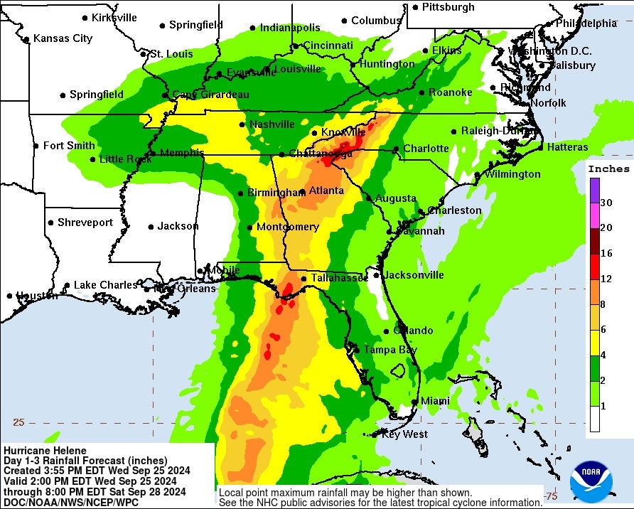
Mapped: Hurricane Helene rainfall
ICYMI: Hurricane Helene could render parts of Tallahassee ‘uninhabitable’ for months
“Catastrophic” storm surge and flooding could render some areas of Tallahassee and the surrounding region “uninhabitable” for weeks or months, the National Weather Service said.
Tallahassee Mayor John Dailey told residents that Hurricane Helene could bring “unprecedented damage” to the Florida city if it remains on its current path.
“We will have countless downed trees. We will have structural damage. We will have loss of power,” Dailey said on Wednesday. “Yes, if our community remains central in Helene’s path as forecasted, we will see unprecedented damage like nothing we have ever experienced before.”
The storm could strengthen to a Category 4 as it makes landfall in Florida late Thursday.
Key messages from officials ahead of Hurricane Helene
Subscribe to Independent Premium to bookmark this article
Want to bookmark your favourite articles and stories to read or reference later? Start your Independent Premium subscription today.
Join our commenting forum
Join thought-provoking conversations, follow other Independent readers and see their replies
Comments